
We are convinced of the importance of nature as a source of trends and cliffs. Therefore, in Sura, knowing and understanding the dynamics of nature opens a world of management possibilities for good health and sustainable development society, people and companies.
* This article was published in Geociências SURA Magazine | Edition 5 | September 2019.
A Global Earthquake Model Foundation (GEM) — Fundação Modelo de Terremoto Global, in Portuguese — is a non-profit foundation, founded in 2009, with the goal of creating a more earthquake-resistant world. The missão da GEM is one of the most complete sources of information on seismic risks reconfirmed globally And, also, guarantee that our products are applied in the management of seismic risks in the entire world.
GEM credits that the development of society and the exchange of knowledge are fundamental and, in line with SURA, committed to transparency, collaboration, credibility and public interest as principles.
The alliance of SURA with GEM was born under the great challenge of knowing and understanding nature and its dynamics, as a method of observation around the earthquake and seismic risk. As a way to take advantage of science and data, SURA and GEM are working together to make all this knowledge available to people and companies, in order to contribute to the construction of resilient cities.
GEM carried out more than fifty training and training offices with specialists from each region of the world. SURA participated in more than 5 offices carried out in Latin America, including receiving one of them in its facilities, in Medellín, in the year 2013.
Seismic resilience management in the world
The objective of GEM is to increase the resilience of communities to seismic events. To achieve this objective, the foundation does not only concentrate its efforts on the calculation of the risk, seismic risk and estimation of the social and economic factors that can increase the physical damage, but also on the development of tools and the exchange of knowledge, which allows the governments and You are responsible for making decisions in companies to work in the prevention, recovery and potentialization of new capabilities, protecting people and saving lives.
To achieve this goal, On December 5, 2018, GEM presented the global model of seismic risk and risk, which provides a reference to evaluate seismic risks. This model, globally comparable and in the public domain, has the following components:
Threat: It allows us to observe which places in the world have the highest or lowest probability of the occurrence of seismic events.
Exhibition: It classifies the quantity of people and the number of buildings, throughout the world, according to their use (residential, industrial and commercial) and their physical characteristics (construction material and number of steps).
Vulnerability: characterizes the behavior of two buildings in the face of a possible occurrence of earthquakes, in accordance with the physical properties of each structure.
Earthquakes do not know borders. For this reason, led by the GEM Foundation, specialists from all countries (scientists and engineers) will join forces to build a common model. Dr. John Schneider states that “Even local specialists are of vital importance in achieving oil and oil models developed at the local, national and regional levels. “This participation stimulates a sense of risk ownership in the community, which is essential to ensure that the public is sensitized and mitigates or reduces the risk.”
Collaboration between the public, private and academic sectors was essential for the development of the global seismic risk modelHowever, research centers, disaster prevention organizations and private supporters, such as SURA, were involved. Thanks to this multiplicity of professional actors, different investigations have been carried out that will serve as input for the development of the global model.
According to Dr. Marco Pagani, coordinator of activities at the foundation, “The seismic risk map, developed by GEM, represents the only major global effort since, in 1999, the first seismic activity initiative was carried out by the Global Safety Availability Program Seismic (GSHAP, in English)”.
The development of the model includes the use of:
- Standardized data from more than 20.000 major earthquakes in the last 110 years, all over the world;
- Information from 70.000 GPS stations;
- Specific information on important active failures;
- Data on buildings and infrastructure around the world, and on the vulnerability of people to earthquakes.
The maps will be sent to GeoSURA, a platform available to SURA so that its clients can access all the necessary information in an agile and efficient way. In GeoSURA, in addition to viewing these maps, users will be able to combine their location information with other data contained on the platform. In this way, with a more open view, appropriate decisions can be made correctly.
How to access this information?
The GEM Foundation publicly makes available the OpenQuake platform, which offers an interactive environment through which users can access information, share data and explore the models and tools developed by GEM for integrated seismic risk assessment. SURA, together with the Geosciences area, manages the platform and supports clients in seismic risk analysis, facilitating the interaction and evaluation of information.
Calculate: It allows users to access the different tools developed by GEM to perform seismic risk and risk modeling and calculations.
To share: Through this module, users can share information and complement existing dice sets.
To explore: It allows users to consult, explore and access information, as well as making tools available for a complete assessment of seismic risks.
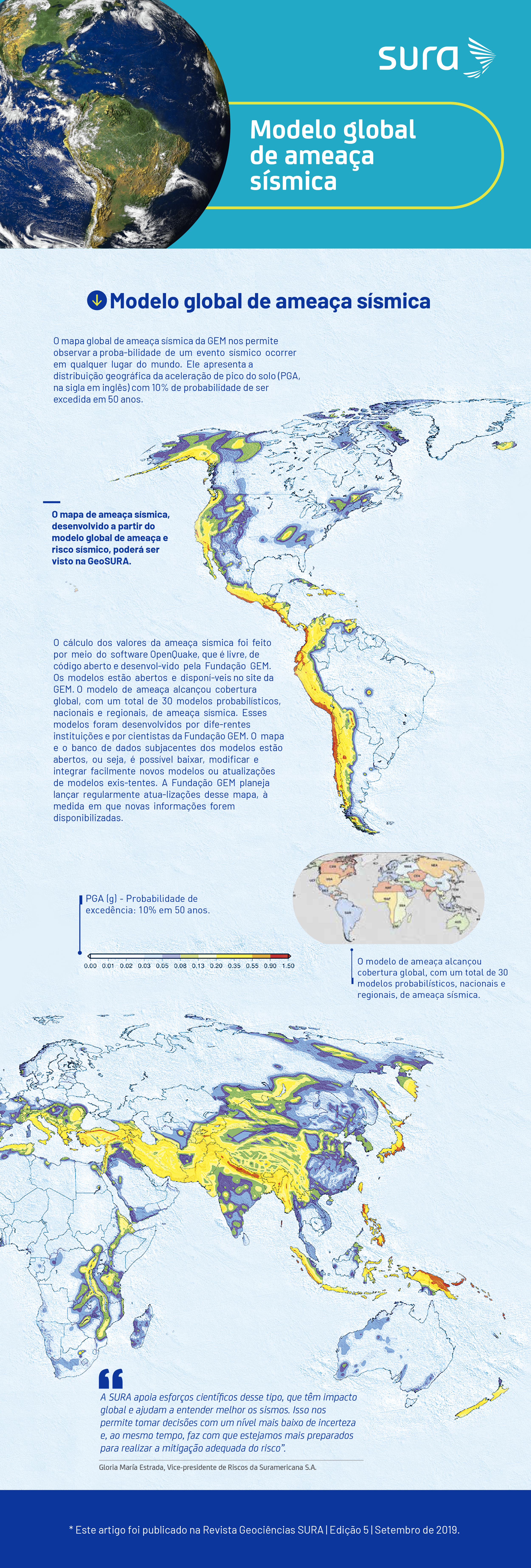
Global seismic ameaça model
The GEM global seismic map allows us to observe the probability of a seismic event occurring anywhere in the world. It represents the geographic distribution of peak acceleration (PGA) with a 10% probability of being exceeded in 50 years.
The calculation of two seismic alarm values was done using the OpenQuake software, which is free, open source and developed by the GEM Foundation. The models are open and available on the GEM site.
The seismic model reaches global coverage, with a total of 30 probabilistic models, national and regional, of seismic monitoring. These models are developed by different institutions and scientists of the GEM Foundation.
The map and data bank underlying both models are open, You see, it is possible to easily download, modify and integrate new models or update existing models. The GEM Foundation plans to regularly update the map, as new information becomes available.
Global seismic risk map
Global Exposure Map: shows the geographical distribution of residential, commercial and industrial buildings in each country. In its elaboration, information on the type of building material, the number of steps and local construction practices (such as the percentage of use of the earthquake resistance standards of each region) is considered.
Global map of human losses caused by earthquakes: shows an estimate of the average annual loss of life due to excessive damage or structural collapse of buildings caused by an earthquake.
Global seismic risk map: presents the geographical distribution of average annual losses in US dollars. In order to obtain a global map, not only the values of each country are compared, but the values are standardized in relation to the construction methods in each country.
The GEM cliff map was intended to be a dynamic product, so it can be updated when new sets of data and models are available. To access technical details on the compilation of mountain and cliff maps and the underlying models, access: www.globalquakemodel.org/gem
What are the benefits of this model?
These are some benefits of the model that allows the prevention of seismic risks and becomes input for making strategic decisions:
- Provides greater knowledge and understanding of seismic risk in all its dimensions: characteristics of the area at the local level
and regional, exposure of people and benefits, physical and social vulnerability. With this information, regulatory bodies can provide better strategies to mitigate the effects of earthquakes; - Allows disaster prevention and assistance agencies to create action and preparation plans for response
of emergencies; - Stimulates investment for the creation of cities and communities that are resilient to seismic effects;
- It facilitates greater knowledge of the physical vulnerability of structures in each region, which stimulates the prioritization of efforts and incentives for programs of improvement and rehabilitation of structures;
- Enables the creation of maps of regional and local cliffs, which are used to manage the adoption of mitigation measures;
- Promotes strategies that allow us to educate and sensitize communities about the importance of risk reduction.
- Support the development or urban structure of territorial planning plans.
The GEM after the global model
The foundation will continue to strongly promote the development and testing of models and tools for seismic risk assessment on a global scale, providing annual updates of two models. In December 2019, it will launch the Global Social Vulnerability and Integrated Risk Map (SVIR). In addition, it will work on other natural phenomena, such as floods, volcanoes, tsunamis and landslides, so that OpenQuake can be used in the evaluation of multiple cliffs.
Sources
- Ana Maria Cortes Zapata. Mathematics and master in applied mathematics at Universidade EAFIT.
- John Schneider. Geophysicist at the University of California, San Diego, United States. Professor in geophysics at the University of Wisconsin.
- Marco Pagani. Master in geological sciences and doctor in Earth sciences from the University of Milão.
- Victor Silva. Master in structural engineering and professor in cliff engineering at the University of Aveiro, Portugal.