

Floods are part of the natural water cycle and bring with them great environmental benefits such as recharging aquifers, creating favorable environments for ecosystems, fertilizing soils and alleviating the excess flow of a flood, avoiding floods downstream of the place where they occur. However, it is necessary to properly manage their associated risks, since they represent one of the most frequent natural phenomena.
* This article was published in Geociencias SURA Journal | Issue 2 | September 2017.
What are floods?
Floods are possibly the most recurrent phenomena in nature. They can be triggered by multiple factors of natural origin such as tropical storms, tsunamis, large-scale macroclimatic phenomena such as ENSO (El Niño Southern Oscillation), mainly in its El Niño and La Niña phases, and torrential rains generated by local climate dynamics.
Depending on their origin, floods can be classified mainly as coastal, pluvial and fluvial.
Coastal flooding: associated with the increase in waves due to other types of natural phenomena such as tsunamis and storm surges, the latter caused when the path and speed of the winds of a tropical cyclone increase the height of the waves on continental soils, flooding areas near the coasts.
Pluvial flooding: related to the insufficient evacuation capacity of rainwater networks, either due to errors in the designs or construction of the system, or due to the occurrence of extraordinary rainfall that exceeds the design parameters.
River flooding: They are associated with the overflow of the flow in natural streams, due to the transit of floods that exceed the hydraulic capacity of the natural channel. They are generated when a considerable volume of water, coming from rain, or from the thawing processes, reaches the main currents of the water basins at such a speed that it exceeds the capacity of the channels to transit the flow.
There are other types of natural mechanisms that can influence the occurrence of floods, such as landslides induced by earthquakes, or by torrential rains, in areas with unstable soils and high slopes.
When landslides occur on the side of a stream, the channel can become blocked by the volume of displaced soil and rock that forms a natural dam. This structure can subsequently fail, causing the volume of water dammed upstream to be suddenly released, traveling downstream with a high concentration of solids from the landslide material.
Depending on their origin, floods can be classified mainly as coastal, pluvial and fluvial.
How to estimate the flood potential of a river?
There are basically three different approaches to estimate the flood potential of a river on a specific stretch of its watershed. Each approach has advantages and limitations compared to the others, and its choice depends on the spatial scale (regional or local) of interest, the specific need of the study and the level of detail desired, guaranteeing in all cases the validity of the approach selected for the specific region to be analysed, as explained by M.Sc. Jaime Trujillo.
Geomorphological approaches
Features: They allow analysis to be carried out on a larger spatial scale. Due to the type of information required, their analysis is economical and rapid.
Sources: regional topography obtained from remote sensors such as satellites. Records of historical river levels.
Usage: Regional flood studies. Urban planning and development studies. Validation of hydrological and hydraulic studies. Pre-feasibility analysis of flood control works design.
Limitations: It is only possible to obtain approximate flood spots. They are not suitable for detailed design of hydraulic works.
Reconstructions of recent major floods
Features: They allow the determination of flood zones based on the occurrence of recent events.
Sources: aerial photographs taken of flooded areas from satellites, manned flights or drones.
Usage: Regional flood studies. Urban planning and development studies. Validation of hydrological and hydraulic studies.
Limitations: By themselves, they do not allow the affected area to be associated with the recurrence of the event. It is not possible to identify the flood potential in areas not affected by historical events, as is the case with those associated with events with a lower probability of exceedance.
mathematical models
Features: They represent the physical conditions that give rise to the processes that cause river flooding. They allow key parameters to be obtained for the design of hydraulic works, such as the speed and depth of the flow. This is the approximation that allows obtaining results with a better level of detail.
Sources: topographic survey of the channel and floodplains. Historical records of hydrometric information on the stream to be analyzed.
Usage: Detailed studies for the design of hydraulic works. Urban planning and development studies
How to estimate flood frequency?
In engineering language related to hydrological and hydraulic analysis, it is common to use the expression “return period” to refer to the probability of a flood of a certain magnitude occurring. What does this mean? The concept of “return period” can often be confusing, as it is often misinterpreted as the exact recurrence of a flood over a specific time period.As an example, when we talk about a flood with a return period of 100 years, we believe we are referring to an event that occurs once every 100 years, which is not entirely true.
In reality, the return period is an estimate of the average interval of occurrence of a flood greater than or equal to a certain magnitude. Thus, for example, when we talk about floods with return periods of 10 years, we mean that when we average the time intervals in which events of equal or greater magnitude occurred, we obtain an average interval of occurrence of approximately 10 years. However, it is possible for more than one event of equal or greater magnitude to occur in a shorter period of time.
This means that a flood with a return period of 100 years has a 1% probability of being equaled or exceeded in any given year, and a flood with a return period of 50 years has a 2% probability of being equaled or exceeded in any given year.
How to mitigate flooding?
There are different situations in which it is unavoidable to occupy areas that present some potential for flooding. The way in which some population centers are structured, or simply the specific requirements associated with the activities carried out by some types of industries, are examples of this. For this reason, it is very important to understand the threat of flooding and thus manage the actions aimed at mitigating it.
Perhaps The most effective mechanism for controlling the threat of flooding in populated centers is through urban planning instruments., which serve to define and restrict land uses in an urban or rural area based on their suitability and different risk levels. However, it is possible to find areas that, even with this initial control by government entities, present a significant risk of river flooding. What to do then?
There are different structural and non-structural measures to mitigate the threat of flooding in those areas that could be affected by an event of this nature.
Structural measures are aimed at the definition, design and construction of civil works that allow mitigating the threat once it materializes.. Dikes, embankments, dykes, retaining walls, dams, reservoirs, dredging of the riverbed and channelling are some of the structural measures that, when properly designed, using the right materials and a correct construction process, can be decisive in mitigating the risk.
Additionally, There are other types of complementary measures that can guarantee resilience of those facilities located in areas with a certain risk of flooding, such as the distribution and arrangement of electrical panels in height, the installation of non-return valves in drainage systems, and the use of materials resistant to contact with water for long periods of time.
Moreover, Non-structural measures focus on risk management associated with this type of phenomenon. These measures include flood threat assessment studies, urban planning instruments, awareness campaigns in environmental protection zones, river flood monitoring and forecasting systems, and the development of action and contingency plans.
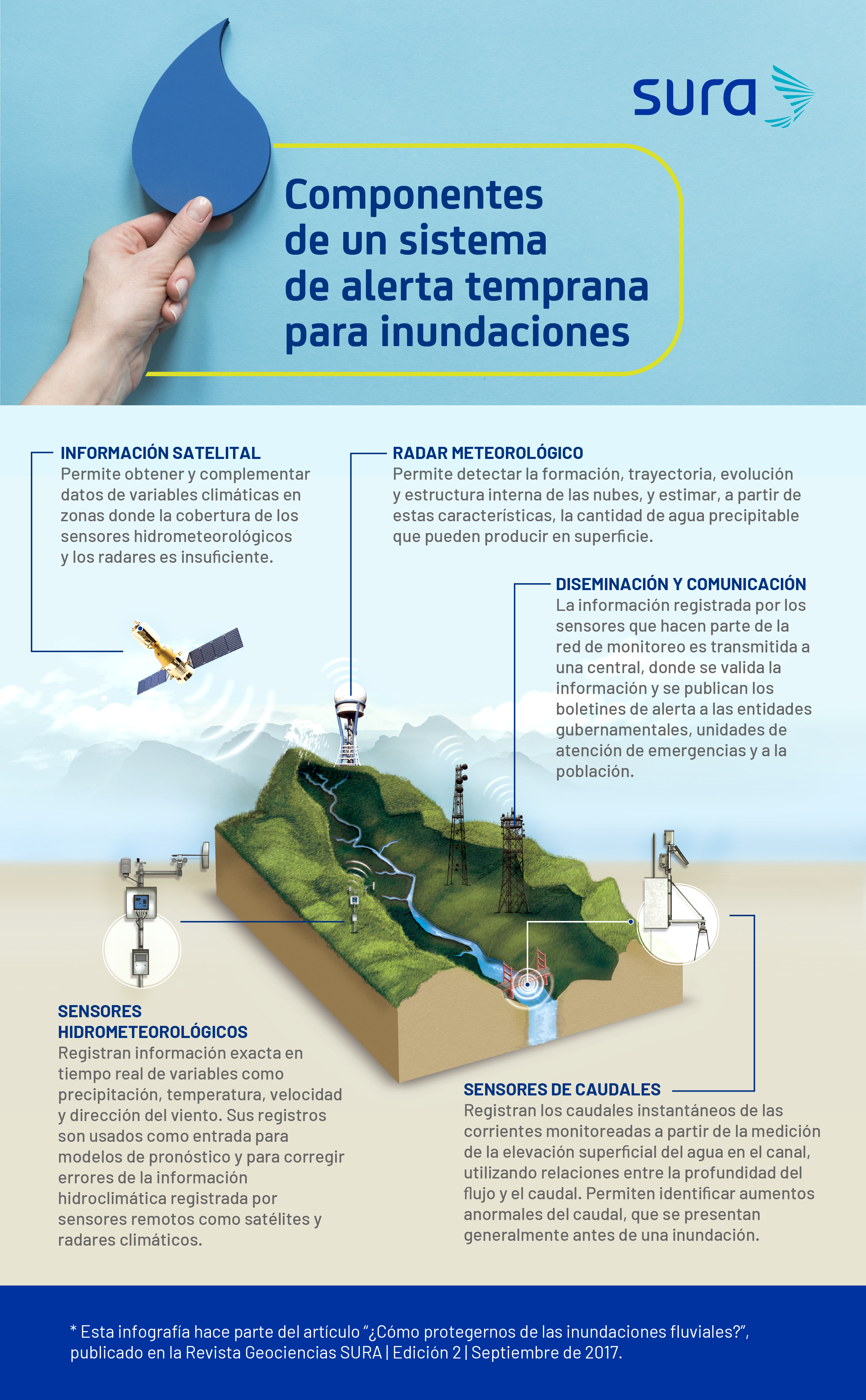
Monitoring and forecasting
Knowing the monitoring mechanisms for hydrometric variables related to floods, and being informed about short- and medium-term flood forecasts, is a key aspect for adequate risk management by government entities, as well as for decision-makers in companies, since knowledge of this information can be decisive in safeguarding people's lives, reducing the economic and material impact, and ensuring business continuity.
Thanks to technological advances related to telemetry, it has been possible to take advantage of information obtained from satellites, radars and other types of hydrometric sensors., in order to monitor physical variables inherent to floods such as precipitation, soil moisture, river levels and flows, which allows anticipating the occurrence of this type of phenomena.
The coupling of these monitoring systems forms the basis of early warning systems, which are commonly found in water basins with a high rate of urban occupation. They are responsible for processing the information captured by the sensors and issuing alerts about the threat of river overflows. They are generally integrated with national and local hydrological and meteorological services.
In addition to the alerts issued by early warning systems, the incidence of certain macro-scale meteorological phenomena on regional climate behavior and the possibility of monitoring these phenomena, allow measures to be taken to be prepared by knowing their consequences at a regional level.
An example of this is the occurrence of El Niño Southern Oscillation in either of its two extreme phases: El Niño and La Niña, which can generate persistent rainfall for a long period of time, depending on the geographic region. This macroclimatic phenomenon presents its first signs in the equatorial Pacific Ocean before its consequences are felt on land, so it is possible to monitor its current state and future impact through indices such as the SOI (Southern Oscillation Index) or the MEI (Multivariate ENSO Index) and the bulletins issued by the National Oceanic and Atmospheric Administration of the United States (NOAA).
Fonts
- Jaime Trujillo D. Civil engineer and M.Sc. in Science from the University of Mississippi.
- Juan Pablo Restrepo. Civil engineer and specialist in Hydraulic Resources from the National University of Colombia.