
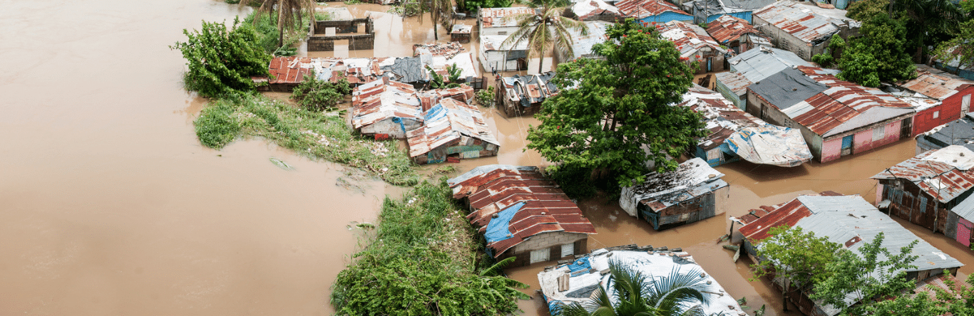
As flooding is part of the natural water cycle and brings with it large environmental benefits – such as recharging the herefers, creating conducive environments for the ecosystems, fertilize them alone and relieve excess waste of water crescent, or that prevents flooding below the place where it occurs. Not so much, he It is necessary to adequately manage the associated risks, since they represent One of the two most frequent natural phenomena.
* This article was published in Geociências SURA Magazine | Edition 2 | September 2017.
What are floods?
As floods are, possibly, the most recurrent phenomena in nature and can be triggered due to multiple factors of natural origin, such as tropical storms, tsunamis, large-scale macroclimatic phenomena – such as ENSO (El Niño Southern Oscillation, in Spanish), mainly in its El Niño and La Niña phases, and torrential rains generated by local climatic dynamics.
Depending on their origin, floods can be classified mainly into coastal, rainy and river floods.
Coastal flooding: associated with the increase in the flow of waves due to other types of natural phenomena, such as tsunamis and storm surges, the latter caused when the trajectory and speed of two winds of a tropical cyclone increase the height of the waves over single continents, or which floods areas close to coast.
Rain floods: related to the insufficiency in the elimination capacity of stormwater networks, due to errors in our projects or in the construction of the system, or due to the occurrence of extraordinary precipitation that exceeds the design parameters.
River flooding: They are associated with the transshipment of the flow of natural currents due to the transit of crescents that exceed the hydraulic capacity of the natural channel. They are generated when a considerable volume of water, coming from the chuvas or two defrosting processes, flows into the main currents of the water basins at a speed such that it exceeds the capacity of two streams to transit or flow.
There are other types of natural mechanisms that can influence the occurrence of floods, such as landslides induced by earthquakes or torrential rainwater. in high slope instáveis solo areas.
When landslides occur on the side of a stream, the stream may be obstructed due to the displacement of a volume of rocks alone and form a natural dam. This structure can fail later, as the volume of water dammed above is released suddenly, descending with a high concentration of solids coming from the slide material.
Depending on their origin, floods can be classified mainly into coastal, rainy and river floods.
How to estimate the flooding potential of a river?
There are basically three different approaches to estimate the flooding potential of a river along a specific path in its water basin. Each approximation has advantages and limitations compared to others and its choice depends on the spatial scale (regional or local) of interest, on the pontual need for the study and on the desired level of detail, or which guarantees in all cases the validity of the approximation selected for a specific region that will be analyzed, as explained by teacher Jaime Trujillo.
Geomorphological approximations
Features: It allows us to carry out analysis on a larger spatial scale. Due to the type of information required, its analysis is economical and fast.
Sources: Regional topography obtained from remote sensors such as satellites. Historical river snow records.
Usage: regional flood studies. Urban planning and development studies. Validation of hydrological and hydraulic studies. Pré-feasibility analysis of the flood control works project.
Limitations: It is only possible to obtain approximate flood spots. They are not suitable for a detailed project of hydraulic works.
Reconstructions of recent large floods
Features: Allows you to determine flooded areas based on the ocorrência function
of recent events.
Sources: aerial photographs taken of flooded areas from satellites,
manned vehicles or drones.
Usage: regional flood studies. Planning studies
and urban development. Validation of hydrological and hydraulic studies.
Limitations: In case it does not allow us to associate the affected area with the event's history. It is not possible to identify the potential for flooding in areas not affected by historical events before events with a lower probability of exceedance.
mathematical models
Features: They represent the physical conditions that give rise to the processes that originate river flooding. It allows us to obtain key parameters for the design of hydraulic works, such as speed and depth of flow. It is an approximation that allows obtaining results with a better level of detail.
Sources: topographical survey of the riverbed and flood plains. Historical records of stream hydrometric information that will be analyzed.
Usage: Detail studies for the design of hydraulic works. Urban planning and development studies.
How to estimate the frequency of floods?
In engineering languages related to hydrological and hydraulic analyses, it is common to use the expression “return period” to refer to the probability of occurrence of a crescent of a certain magnitude. But what does this mean? The concept of “return period” can often be confusing, as it is often misinterpreted as an exact recurrence of a crescent in a specific period of time. For example, when we talk about a crescent with a return period of 100 years we believe that we are referring to an event that occurs once every 100 years, or that is not completely correct.
The truth is that the return period is an estimate of the mean interval of occurrence of a crescent greater than or equal to a certain magnitude. Thus, for example, when we talk about crescents with return periods of ten years, we are referring to the fact that when we average two time intervals in which events of equal or greater magnitude occur, we obtain an average interval of occurrence of approximately ten years. However, it is possible that more than one event of equal or greater magnitude occurs in a period of shorter time.
This means that a crescent with a return period of 100 years has a 1% probability of being equaled or exceeded in any year and a crescent with a return period of 50 years has a 2% probability of being equaled or exceeded. in any year.
How to mitigate flooding?
There are different situations where it is unavoidable to occupy areas that have some potential for flooding. In the way that some population centers are structured or simply the specific requirements associated with the activities carried out by some types of industries, these are the examples. For this reason, it is very important to understand the flood risk and how to manage the floods prone to mitigation.
Perhaps The most effective mechanism to control flooding in populated centers is through urban planning instruments., they serve to define and restrict uses only in an urban or rural area based on their capacities and different levels of cliff. However, it is possible to find areas that, even as first controlled by government entities, present a significant risk of river flooding. Então, what to do?
There are different structural and non-structural measures to mitigate the risk of flooding in areas that could be affected by a natural event.
Structural measures are aimed at defining, designing and constructing civil works that allow mitigation of the disaster if it materializes. Barriers, embankments, dikes, retaining walls, dams, reservoirs, dredging and canalization do not require some structural measures that, with an adequate design, use of competent materials and a correct construction process can be decisive in risk mitigation.
Additionally, There are other types of complementary measures that can guarantee resilience installations located in areas with certain risk of flooding, such as the distribution and disposal of electrical panels in high places, the installation of non-return valves in disposal systems and the use of materials resistant to contact with water for long periods.
Moreover, non-structural measures are concentrated on risk management associated with that type of phenomenon. The flood assessment studies, the urban planning instruments, the awareness campaigns in environmental protection areas, the river flood monitoring and prognosis systems, and the elaboration of water and contingency plans are part of this type of measure.
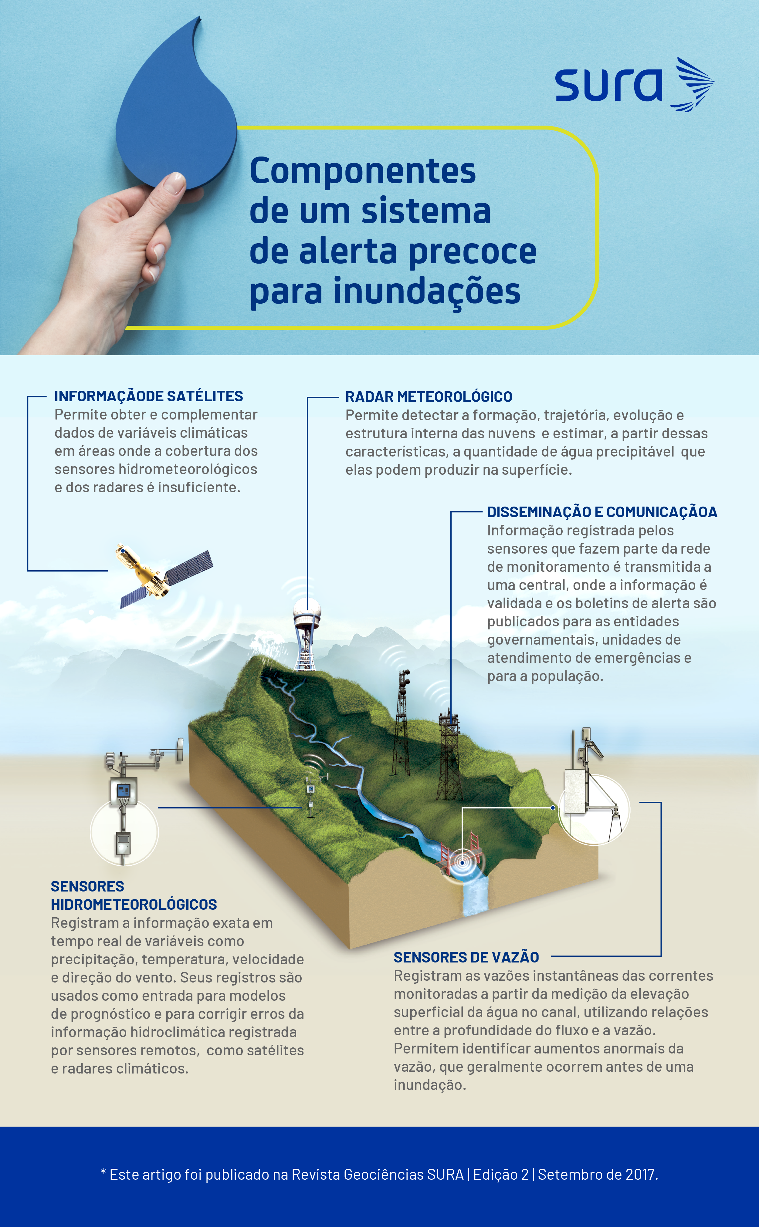
Monitoring and prognosis
Knowing the monitoring mechanisms for hydrometric variables related to floods and being informed about flood forecasts in the short and medium term constitutes a key aspect for adequate risk management by government entities, as well as for being responsible for the decisions of companies. , because the knowledge of this information can be decisive to safeguard the lives of people, reduce the economic and material impact and guarantee the continuity of two businesses.
Thanks to technological advances related to telemetry, it is possible to provide information obtained by satellites, radars and other types of hydrometric sensors, with the objective of carrying out the monitoring of physical variables inherent to flooding, such as precipitation, umidade of the sun, snow and vazões of rivers, or that allows the occurrence of this type of phenomenon to be anticipated.
Together with these monitoring systems, they constitute two early warning systems, which are commonly located in water basins where there is a high rate of urban occupancy, and are responsible for processing the information captured by the sensors and issuing alerts about the area. of transshipment two rivers. They are generally integrated into national and local hydrological and meteorological services.
In addition to two alerts issued by early warning systems, due to the incidence of certain macroscale meteorological phenomena on regional climatic behavior, the possibility of monitoring these phenomena allows us to take precautionary measures to know their consequences at the regional level.
An example is the occurrence of the El Niño Southern Oscillation, in Spanish in any of its two extreme phases: El Niño and La Niña, as we can generate persistent showers for a long period, depending on the geographical region. This macroclimatic phenomenon presents its first signs in the Equatorial Pacific Ocean before its consequences are noted on the ground, so it is possible to monitor its current state and its future impact through indices such as the Southern Oscillation Index (SOI). ) The ENSO Multivariate Index (MEI) and two bulletins issued by the National Oceanic and Atmospheric Administration of the United States (NOAA, in English).
Sources
- Jaime Trujillo D. Civil Engineer and Master in Sciences at the University of Mississippi.
- Juan Pablo Restrepo. Civil engineer and specialist in Hydraulic Resources at the National University of Colombia.