
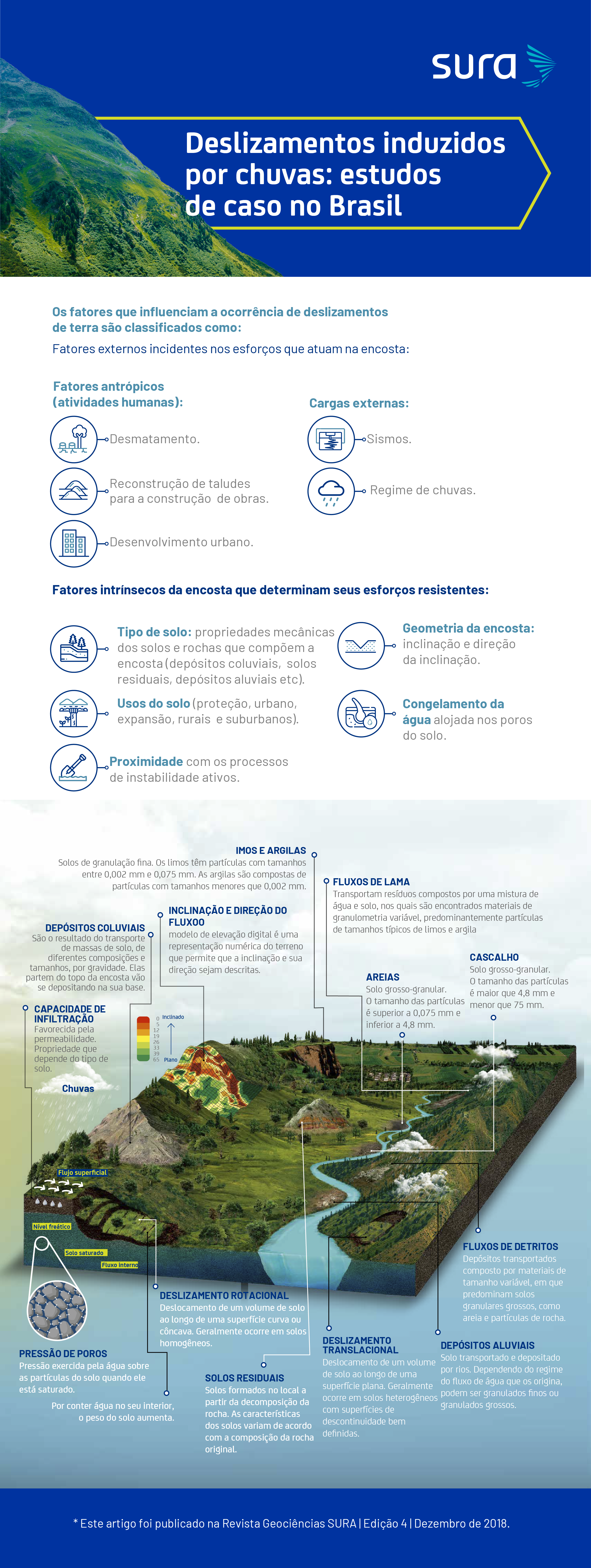
A slip or movement in mass is the displacement of a certain amount of volume of material in the direction of lower levels of a coast. This phenomenon occurs due to a loss of balance between the forces of action, the imposts due to gravity or other loads, and the resistant stresses of the shore material.
* This article was published in Geociências SURA Magazine | Edition 4 | December 2018.
Effects of water not only on its potential to induce landslides
The presence of water is not only a factor that makes up most of the landslides, since it increases the stresses and loss of resistance on only the coast.
The relationship between flood intensity and water storage capacity is not only determining for the occurrence of different types of landslides. If the intensity of the chuva is greater than the capacity of water storage alone, saturation of the surface will occur quickly, a situation that favors surface landslides.
On the other hand, it is not the case of chuvas of lower intensity, but of longer duration, as saturation can only reach deeper snows, leading to deep slides.
The rate of movement of slid material when a slope collapses can vary from a few millimeters per hour to rapid slides, where large movements are generated in just a few seconds.
Landslides are a global phenomenon of frequent occurrence and significantly favored by climatic and geomorphological conditions. Different institutions, such as NASA or the Disaster Effects Inventory System (DesInvent), are dedicated to monitoring and recording historical landslides from local to global scales.
The landslide inventories developed by these institutions represent a valuable source of information for the understanding of the phenomenon and the varying localities that influence its occurrence and facilitate the development of models for assessment, monitoring and management of cliffs.
The Global Landslide Catalog (GLC) is a compilation of all historical landslides induced by chuva, reported in media, disaster data banks, scientific reports or other sources. The GLC was developed in 2007 at NASA's Goddard Space Flight Center (GSFC).
What happened in Rio de Janeiro on January 11, 2011?
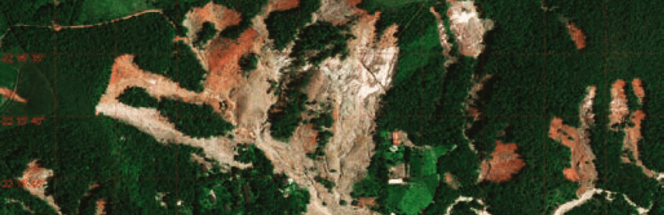
One of the most important cases of landslides caused by chuvas in South America was that which occurred on January 11 and 12, 2011, in the Serrana Region of Rio de Janeiro. This case was listed by the UN as the eighth largest landslide in the world in the last 100 years.
In 2011, some key aspects for the occurrence of various landslides in the Rio de Janeiro region foram:
- Ingreme or mountain topography with high slopes.
- Coasts formed by soles with high susceptibility to loss of resistance due to water saturation.
- Anthropic factors that generate the clearing and reconfiguration of slopes that allow the urban development of the area.
- Strong chuvas. According to the National Institute of Meteorology, rainfall of 280 mm was recorded in a 24-hour period, between January 11 and 12, 2011, in the city of Nova Friburgo. It is important, for comparative purposes, to mention that The historical average precipitation no more than January is in the city of 277 mm, which indicates that the precipitation generated in 24 hours was similar to the historical average of the month. This high volume of chuva caused approximately 3.500 landslides in the area, mainly being surface translational types and debris flows.
How to manage the risk of chuva-induced landslides?
In the global and local context, there are numerous investigations that, together with the technological advances in the monitoring of hydrometeorological variables and the state of the art in semantic engines for tracking online news, show a very positive path towards landslide risk management associated with chuva.
A fundamental key is the information processing of the factors that control the stresses and resistance of the coasts, together with the estimation of two representative intervals of intensity/duration of the storms that can trigger landslides in a specific area. This way allows the validation of predictive landslide models, which serve to:
- Landslide early warning systems;
- Design and construction of engineering works to control instáveis or potentially instáveis areas;
- Territorial planning plans that provide guidelines for the most appropriate use only in areas susceptible to landslides.
These analysis techniques, together with ground instrumentation and remote sensors, show great possibilities to better understand these phenomena and, as well, better manage the related risks. Since we know little about the mechanisms of occurrence of landslides caused by chuva, it is possible to plan and implement concrete actions with a high level of information.
It is important not to lose sight of the fact that there are dynamic processes that depend not only on the physical conditions of nature, but also on urban development in the area of interest. The analysis models will continue to improve so that each time we can estimate with more credibility the patterns of intensity and duration of the chuvas that induce landslides. It is important to know that there are mechanisms to analyze and manage this risk, based on a tool that combines regional and local aspects that, in turn, allows guiding decisions in the most favorable way to protect life, property and productivity.
Sources
- Gabriel R. Toro. Civil Engineer at the National University of Colombia, Master and Doctor in Civil Engineering at the Massachusetts Institute of Technology.
- Kevin B. Clahan. Bachelor's degree in Earth Sciences at the University of California and Master's degree in Geology at the State University of San José.