
Various studies on earthquake-induced landslides confirm the importance of the potential for damage from these phenomena around the world. Adequate cliff management allows us to be prepared not only to protect the population, but also to minimize associated material losses.
*This article was published in Geociências SURA Magazine | Edition 2 | September 2017.
Landslides normally occur at various geographic points as part of the natural evolution of the landscape. Many slides happen on natural slopes, but they also happen on slopes constructed by humans. Their causes vary, but a significant percentage of them is generated by the occurrence of seismic events.
When there is an earthquake, the movements produced in the ground are sufficient to cause a fall in the slopes or slopes that were in conditions that were marginally or moderately present before the earthquake. The associated damage can vary from insignificant to hundreds of large landslides, depending on the geometry and material characteristics of the slopes.
Can a seismic event induce landslides?
To answer this question, it is necessary to know which factors control the susceptibility of a slope or slope to a landslide, as well as the effects that seismic waves generate. The historical records of earthquake-induced landslides provide very useful evidence to understand their occurrence mechanisms and, consequently, to identify the most efficient actions for their mitigation.
The potential for landslide of a slope depends on many factors.Among these are its geological and hydrological conditions, uses of the sole, topography (height, inclination and direction of the inclinations), climate, resistance characteristics of the profile of the sole or rock and moisture content.
When there is an unfavorable combination of these factors, or the terrain is prone to slipping. However, a series of external factors – such as seismic events, intense floods and human activities, such as deforestation, agriculture and infrastructure construction – can be dissipators of landslide phenomena.
It is important to take into consideration some indicators of instability of a decline or slope that, if not properly managed, can trigger a slide. The areas where we find these manifestations are more prone to landslides when a seismic event occurs.
Ladeiras in solo:
- Tilting of doors and doors or difficulty in getting dates.
- Fendas, settlements and inclination of buildings.
- Traction fences do not rise on the slope or slope outlining the surface of the slope.
- Foundation of the summit of the slope.
- Trees or inclined or curved posts.
- Growth at the base of the slope or slope.
- Fault surface.
Rock slopes:
- High density of fractures and discontinuity or evidence of material detachment.
Various investigations have studied landslides induced by earthquakes throughout history. The first formal scientific study on the subject was carried out in 1783 on the landslides induced by a series of earthquakes that occurred in Calábria, in Italy. More recently, in 1984, David K. Keefer published a study analyzing the correlation between more than 300 earthquakes in the United States (1958-1980) and the landslides induced by them.
This study has obtained some important correlations between seismic magnitude and variables such as: a) areas affected by induced landslides, b) maximum distance between induced landslides and epicenter, c) types of landslides generated, among others. These studies will provide a basis for a growing number of investigations into the variables that trigger landslides associated with earthquakes., which continue to be carried out today.
Landslides induced by earthquakes in El Salvador
Various studies on earthquake-induced landslides confirm the importance of the potential for damage from these phenomena around the world. One case that we can cite in Central America corresponds to the landslides induced by the earthquake that hit El Salvador on January 13, 2001.
This earthquake had a magnitude of 7,6 (Mw) and was generated at a depth of 60 km. This earthquake and its associated landslides affected tens of thousands of homes and buildings, energy infrastructure, road infrastructure and agriculture. It is important to mention the large number of landslides produced on high slope slopes, mainly in the Bálsamo mountain range.
Earthquake-induced landslides in Nepal
Another clear, very recent example of landslides induced by earthquakes was generated by an event that occurred in Nepal in April 2015, where an earthquake with a magnitude of 7,8 (Mw) and located at a depth of 15 km, with the epicenter not in Kathmandu, It caused more than six thousand slippages and economic losses of billions of dollars in the assets that form this voucher.
The characteristics of the event recorded and the distribution of damage and landslides caused will allow us to establish the incidence of earthquake amplification due to topographic effects and the type of only Due to the fact that this region has a complex convex topography, with accentuated slopes of the terrain and flexiveis of different types.
Landslides induced by earthquakes in Colombia
For the specific case of Colombia, there is a significant amount of landslide records that were triggered by different seismic events. Some events can be cited, such as the case of the Murindó earthquake, on October 18, 1992, with a magnitude of 7,1 (Mw), which caused numerous landslides along the banks of the Murindó River and caused its damming.
A similar case occurred on June 6, 1994, when an earthquake with a magnitude of 6,8 (Mw) with its epicenter in the basin of the Páez River induced large landslides, generating an avalanche that devastated a large part of the municipality of Páez and devastated nearby of 40.000 hectares of land during its passagem.
How to do adequate rock management for earthquake-induced landslides?
To adequately manage the susceptibility of landslides induced by earthquakes, we must consider the development of technical studies and the elaboration of surveys of active landslides focused on defining zones with different levels of weather in the region of interest.
The landslide maps are relevant for the planning, execution or rehabilitation of works both in infrastructure and buildings, as well as for the quantification of the associated risks, which are used to validate the cost-benefit relationship of the possible prevention and prevention alternatives. mitigation, as highlighted by Master Gabriel Toro, researcher and assessor recognized for his collaborations in Seismic Engineering.
Not only that, but with respect to modeling seismic scenarios to estimate landslide risk levels, cities can prepare to protect the population and minimize material losses associated with earthquake-induced landslides. A clear example is the work carried out by the local government of the city of Aizawl, in Mizoram, in India, which was affected by landslides induced by earthquakes.
In order to obtain some recommendations to manage this risk and protect the population, its buildings and infrastructure, a series of technical studies was carried out by our master Kevin Clahan, responsible engineering geologist of the North American company Lettis Consultants International Inc. (specialist in studies of geological cliffs) and a team of specialists in seismology, geology, geotechnics and structures will analyze the potential landslides associated with the expected losses in a typical earthquake scenario.
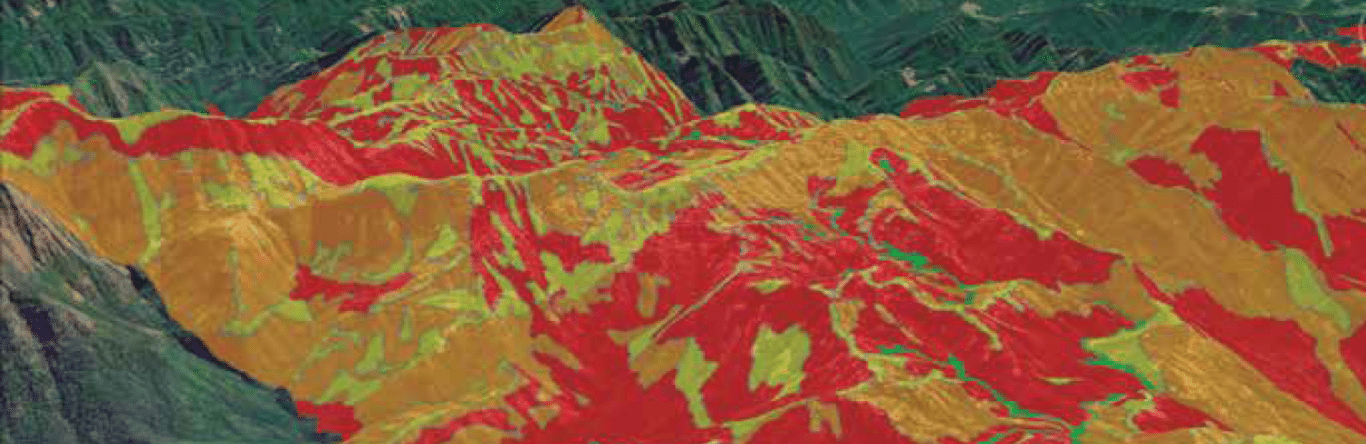
Two results from this study were a zoning map of the area of landslides induced by the analyzed earthquake scenario, which presents essential elements to guide the plans for territorial planning and urban development in a structured manner.
The landslide maps are relevant for the planning, execution or rehabilitation of works both in infrastructure and buildings, as well as for the quantification of the associated risks, which are used to validate the cost-benefit relationship of the possible prevention and prevention alternatives. mitigation.

Sources
- Gabriel R. Toro. Civil Engineer of the National University of Colombia, master and doctor in Civil Engineering of the Massachusetts Institute of Technology.
- Kevin B. Clahan. Graduate in Earth Sciences from the University of California and Master in Geology from the State University of San José.