

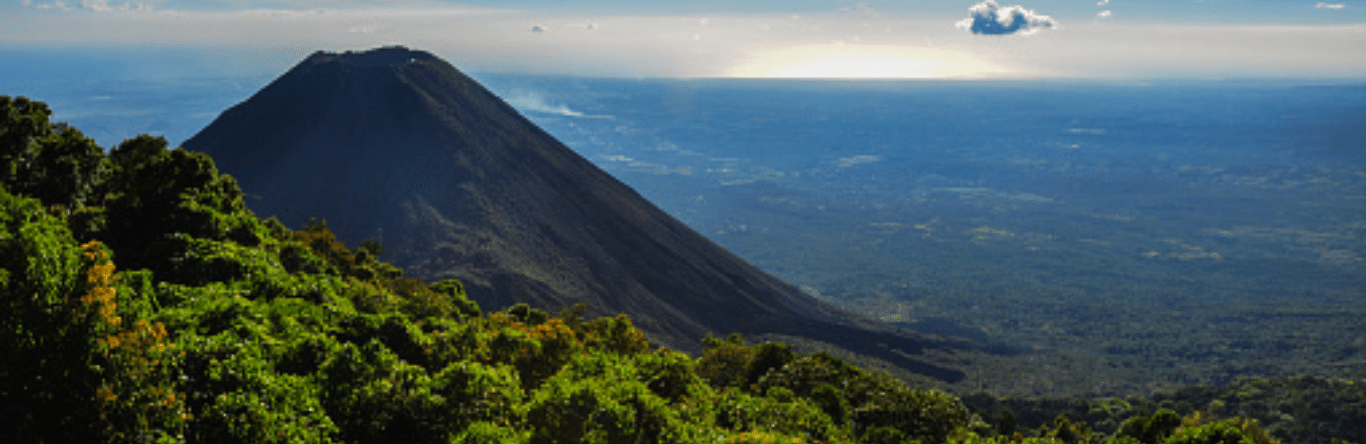
Vulcões are based on the geographical particularities of some countries, giving a special touch to the local landscape and attracting thousands of tourists. In addition to hiding histories, cultures and economies that reveal and identify the regions where they are located. What is it for and how can it affect or benefit us?
* This article was published in Geociências SURA Magazine | Edition 5 | September 2019.
Imposing and majestic, the vulcões have been a source of inspiration for various cultures throughout history. The word “vulcão” comes from the Latin Vulcan, or god of fire in Roman mythology, responsible for forging the iron and raising the weapons carried by the gods and heroes of Rome.
However, there were other cultures, such as the Mayans and Astecas, who fervently cultivated the Vulcões. They prove that the people live in their depths and are responsible for the formation of two meteorological phenomena necessary to guarantee agricultural production.
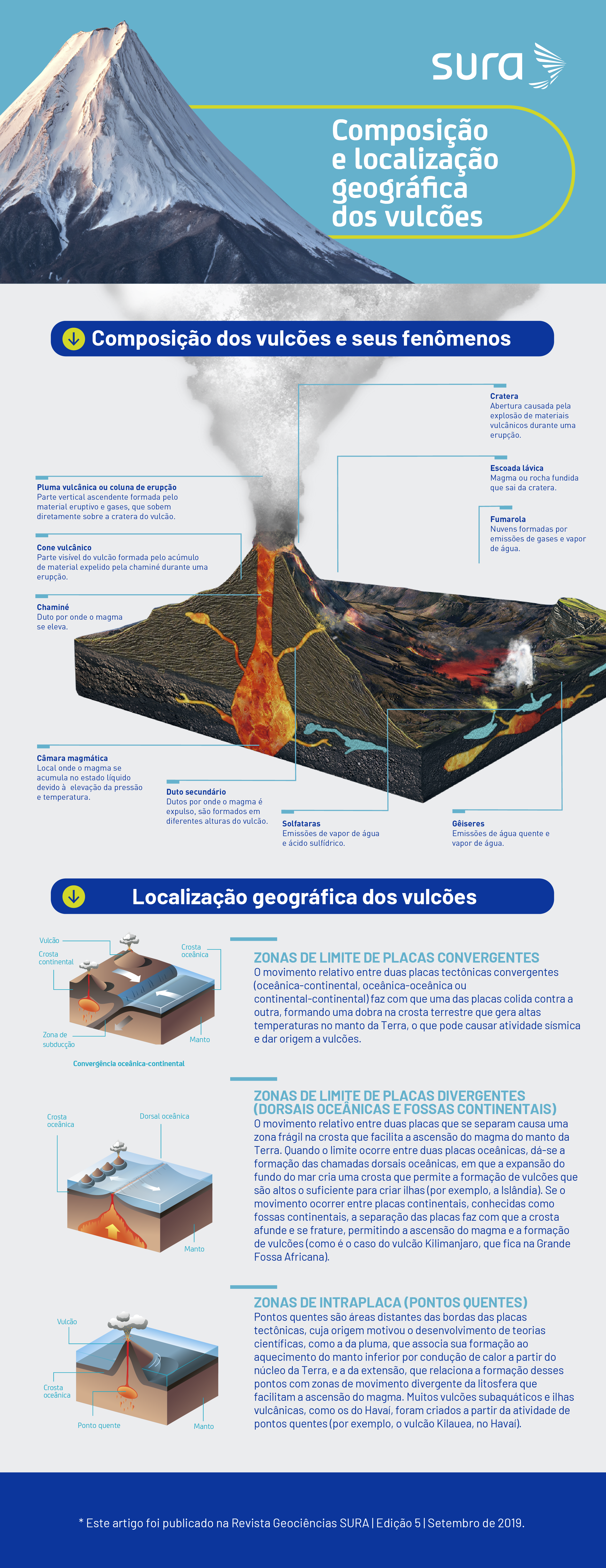
The vulcões are part of the geological cycle of the Earth, which is the set of phenomena or natural events that transform the crust and the mantle of the surface., where a mixture of molten rock, gases and other components — called “magma” — on the internal part accumulates on the surface, giving rise to various changes, whose forms depend on complex processes that are subject to the presence or absence of gases and the formation, ascent, chemical composition and emission of magma.
How are volcanic eruptions classified?
The eruption is a natural phenomenon that consists of the expulsion of different gases and materials from the interior of the Earth, whose magnitude and intensity depend, in large part, on the chemical composition of the magma and its viscosity, directly related to the silica theory. Thus, as the silica theory becomes higher, the magma will be more viscous and will cause more eruptions, which will also be much more explosive than those caused by magmas with a lower silica theory.
Vulcões enter an eruption in different ways. The classification of the eruption is based on a vulcão that has presented similar behavior in history. However, there are volcanoes that have one or more types of recorded eruptions, therefore some cannot be classified into a specific type.
Icelandic: Non-violent eruptions caused by a fissure in the earth's crust, where lava flows and travels long distances. Example: Decan planalto, India.
Havaianas: small violent eruptions with abundant expulsion of very fluid or liquid lava. Example: Mauna Loa, Havaí.
Strombolian: moderate or sporadic explosions of fluid lava, abundant and violent gases and fragments of molten rock, which are called pyroclasts. Example: Stromboli, in Lípari, Italy.
Vulcanians: explosions, which vary between moderate and violent, of blocks of lava and cinders, accompanied by other fragmented materials that solidify quickly. They are characterized by generating a number of webbing in the shape of a cogumelo. Example: Vulcano, Italy.
Sub-Plinian, Plinian, Ultra Plinian: extremely violent execution of belts, at high altitude and in the shape of a cogumelo. They are characterized by alternating eruptions of pyroclasts and lava flows, creating clouds of fire that, when cold, produce precipitation of zinc. This type of volcanic eruption is named after Plínio, or Velho, who died in the eruption that occurred on Monte Vesúvio, in the year 79 AD. Example: Vesúvio, Italy, and Monte Pinatubo, Philippines.
Fights: Violent explosions of very viscous lava that consolidates quickly, causing crater clogging. As the gases do not come out, a large pressure is created inside the volcano, so that its walls give way to the lava and is expelled from the sides. Example: Mount Pelée, Martinique.
“Currently, the Geological Service of Colombia is promoting the need for the population to know history and learn about the process of formation of the territory of the country, otherwise, we will condemn future generations to situations similar to the destruction of Armeiro. In nature, what we fear to do is that the vultures are ready to erupt. “As people, you are responsible for understanding nature and making correct decisions.”
Doutora Marta Lucía Calvache Velasco, technical director of geographic areas of the Colombian Geological Service (SGC).
How does volcanic activity work?
Volcanic activity is associated with different types of manifestations, including the life cycle of two volcanoes, which depends on when the last eruption occurs. Isso allows the vulcões to be classified as active, inactive and extinct.
Embora esse geologico tempo is not clearly defined, Some geologists consider that active vultures only present eruptions, gas releases and earthquakes, among other phenomena, in the last 10.000 years. This is the case of Mount Kilauea, not Havaí, considered one of the two most active volcanoes in the world due to its constant eruptions of lava.
Inactive volcanoes are those that did not enter the eruption more than 10.000 years ago, but there are geological characteristics with the potential to generate eruptions at some point. Mount Pinatubo, in the Philippines, was considered inactive because it did not manifest phenomena for several centuries, however, in June 1991, it caused the second largest vulcanic eruption of the 25th century, releasing 30 to 0,5 thousand tons of enxophren dioxide in the Philippines. stratosphere, which caused, for two consecutive years, a decrease in the average temperature of the planet by XNUMX °C.
Extinct vultures are only those that have no more capacity to enter the eruption, because its magma source disappears due to the geological conditions close to the vultures. O Monte Kulal, not Quênia, is considered an extinct volcano.
Embora os vulcões sejam formadores de paisagens e contribuam para la identidade das regiões, eles também uma umastra da incrível força da natureza, a point de Large volcanic eruptions have changed the course of the history of some cities.
In the case of Pompéia and Herculaneum, which was devastated by the eruption of the Vesúvio volcano, in Italy, in 79 AD Approximately ten centuries ago, Pompéia was partially excavated by archaeologists who discovered signs of life and luxuries of the ancient Roman Empire.
According to historical records and scientific studies of the region, it is proven that the Vesúvio eruption began with steam discharges and the formation of an eruptive cloud, composed of cinders and fragments of pumice (igneous rock also chamada pedra-pomes), which was condensing on asities.
However, the greatest effect caused by the volcano was the formation of pyroclastic clouds, which are avalanches or currents of gases, fissures and incandescent rocky fragments (pyroclasts) that descend at high speed along the coasts of the volcano.
Size, magnitude and intensity of volcanic eruptions
Volcanic eruptions can be measured in terms of magnitude, which corresponds to the total mass of matter that enters the eruption (kg), and intensity, which is the rate of eruption or speed of magma emission (kg/s or m3/s ), which can be estimated from the height and shape of the eruptive column and the area over which the eruptive material is distributed.
To determine the size of a volcanic eruption, volcanologists Christopher Newjall and Stephen Self developed a magnitude scale called the Volcanic Explosivity Index (VIE), which varies from 0 to 8, based primarily on the volume of material that enters the eruption. during an explosion at the height of the eruptive column.
This scale starts at 0 for eruptions that produce less than 0,0001 km3 of material. From IEV 1 onwards, it becomes logarithmic, that is, each acreth on the scale increases the amount of material expelled 10 times.
Impacts and benefits of vulcões
Volcanic activity has several effects and influences that depend on the characteristics of the volcano and its impact on a regional and, at the same time, global scale. The knowledge of two vulcões, their dynamics and their inter-relationships with communities, the environment and my construction are fundamental to manage its risks and take advantage of its benefits.
These are some impacts and benefits that we can highlight:
- Formation of vulcanic islands: vulcões empurram materials for the surface of two oceans, which can lead to the formation of islands that become habitable and tourist areas.
- Tsunami: caused by landslides on vulcan coasts or volcanic eruptions.
- Gases: we can reduce solar radiation and the average temperature of the planet for a certain period of time.
- Ballistic projects: incandescent fragments of volcanic material expelled at high speed, causing fires and destruction of infrastructure.
- Lahars or mud avalanches: composted by a mixture of volcanic material and intense gulf water, melting of ice or snow at the top of the volcano, which can cause destruction of vegetation, crops, infrastructure and flooding.
- Lava flow: can damage crops, cause forest fires and destroy infrastructure.
- Help in the formation of new ecosystems.
- Pyroclastic flows: avalanches of gases, cinders and solid fragments of magma that affect the environment and ecosystem.
- Damn.
- Acid chuva: produced by gas emissions that come into contact with chuva, causing increased acidity in rivers, lakes and alone, or that impacts fishing, agriculture and livestock.
- Geothermal energy: generation of electricity from the energy present, in the form of heat, not inside the earth.
- Extraction of useful raw materials for civil construction and the chemical and pharmaceutical industries.
- Increase in respiratory, skin and eye diseases in the population.
- Promotion of research.
- Enrichment of only important nutrients for crops.
- Pollution of nearby water sources.
- Geotourism: formation of hot springs and volcanic slabs.
- Earthquakes: they can cause damage to infrastructure and landslides on coasts.
- Cinzas: provides only nutrients that increase your fertility.
- Formation of herefers and springs from the water contained in volcanic rocks.
Threat maps, monitoring and early warning systems
Volcanic eruptions, unlike other geophysical phenomena, such as earthquakes, generally have an associated precursor activity, which varies from days to months. This activity can allow warning signals to be detected in time and generate risk anticipation, planning and mitigation mechanisms.
The analysis of the monitoring of this type of signal allows the generation of prior alerts, allowing the detection of deformations on the surface of the sole, temperature alterations, gas emissions and/or webbing, and seismic activity, among other parameters that help in estimating the probability of an eruption. possa ocorrer.
Volcanic observatories are organizations responsible for monitoring active volcanoes and providing information on the state and level of volcano activity, so that municipal authorities can issue early warnings about a possible eruption. Therefore, they play a fundamental role in risk management and reduction.
These observatories have protocols for warning levels of volcanic cliffs, but it differs in each country because it depends on the type of vulcão and the needs of the population. Além disso, there is no internationally unified system for this fim.
The International Civil Aviation Organization (ICAO), a specialized agency of the United Nations, developed a universal warning system that uses four cores (green, yellow, orange and red) that represent the conditions of flight and assistance to aircraft. to avoid clouds of weeds that can become potentially dangerous.
Another mechanism for managing cliffs on the maps of volcanic ameaça, that allows us to represent, by area, the possible zones affected by different phenomena that may occur during an eruption, providing detailed information so that it is possible to make territorial planning decisions, development of contingency plans, population preparation and risk mitigation.
The Popocatépetl volcano, 43 kilometers from the city of Puebla, in Mexico, currently active, is 5.426 meters above sea level. Its name, coming from Nahuatl, means “smoking mountain”. Geographically, this vulcão joins, to the north, as the Iztaccíhuatl vulcão, which means “sleeping woman”, whose shape contains several peaks that shape the silhouette of a woman standing from the front to her head and as her hair extends to the opposite side of her body, which was a source of inspiration for the creation of mythological legends that were transmitted from generation to generation. in generation.
On November 13, 1985, the Nevado del Ruiz volcano, in Colombia, had an eruption of magnitude 3 on the IEV scale. Although this magnitude could be considered moderate, it was sufficient to make the pyroclastic flows emitted by the eruption cause the melting of ice and snow, causing lahars that were channeled through 6 rivers and causing effects in several municipalities, specifically not the municipality of Armero, located in the department of Tolima.
This event marks the formal start of the Colombian Geological Service Volcanic Monitoring Program, which allows the behavioral models of the most active vulcões to be obtained and provides timely information, making possible not only the comprehensive management of the risk but also the exploitation of the natural resources in the best interest of the population.
Sources
- Catalina Bedoya. Civil and Sanitary Engineering for the University of Antioquia.
- Marta Lucía Calvache Velasco. Geologist from the National University of Colombia. Geothermal specialist from the University of Auckland, New Zealand. Master from the University of the State of Louisiana and Professor from the University of the State of Arizona, both in the United States.
- Victoria Luz Gonzalez Perez. Civil Engineer at the University of Medellín, specialist and master in Earthquake Resistant Engineering at the EAFIT University.