
What are earthquakes? How do they originate? What is the purpose of monitoring them? Knowledge and its appropriation are key to managing seismic risk. Knowing their origin, magnitude and intensity, for example, allows planning the development of infrastructure projects in a way that guarantees safety and sustainability, at the individual, business and government levels.
* This article was published in Geociencias SURA Journal | Issue 1 | November 2016.
An earthquake is the movement and vibration of the Earth's crust due to a rapid release of energy accumulated between tectonic plates or in a fault system, resulting from a rupture of the rock, and which propagates through seismic waves.
The propagation of these waves, recorded by measuring instruments, is sometimes perceived by people and causes movements in buildings.
What is the origin of earthquakes?
The most widely accepted explanation for the origin of earthquakes is based on the modern theory of plate tectonics, whose basic hypothesis is that the Earth's surface, called the crust, is made up of large blocks called plates, which move relative to each other. Relative deformation between the plates occurs in narrow zones near their edges.
This deformation can occur slowly and continuously (aseismic deformation: it does not produce earthquakes) or suddenly, in the form of earthquakes. Because deformation occurs predominantly at the edges of the plates, this is where the highest concentration of earthquakes occurs. The global historical seismicity map confirms this condition, which has given strong support to the theory of plate tectonics.
When the plates of the Earth's crust move, they produce earthquakes and release accumulated energy that propagates in the form of seismic waves.The measurement of these waves has been one of the indirect fields of research that has allowed us to advance in the knowledge of the internal structure of the planet, because the different types of seismic waves propagate differently through the materials that make up the layers of the Earth.
There are other causes of earthquakes such as volcanic activity and some human activities. Earthquakes associated with volcanic activity result from the intrusion or movement of magma or volcanic fluids, which can cause the rupture of the continental crust; they generally affect very specific areas.
As for human activities, the underground detonation of chemical explosives or nuclear devices and the construction of reservoirs can generate seismic activity induced by changes in stress concentrations that can reduce the strength of rocks with the potential to break. In general, in this type of activities and projects, importance is given to the development of prior studies to prevent induced seismic activity.
What is the magnitude of earthquakes?
The size of an earthquake is a very important parameter and has historically been described in different ways. Prior to the development of modern seismic instrumentation, the methods for determining it consisted of qualitative descriptions of its effects, which implied a combined measure of the earthquake size and its damage. This posed a difficulty because The damage depends not only on the magnitude and depth, but also on the quality of the design and construction of the buildings.
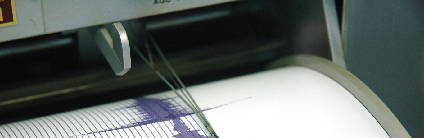
Modern seismographic stations have made it possible to develop quantitative measurements of the magnitude of earthquakes. If any equipment revolutionized the field of seismology, it was the seismometer invented by Harry O. Wood and J. A. Anderson in 1922, which became a reference for the development of seismic research. Based on measurements made with this seismometer, the Richter magnitude scale was developed in 1935, named after its author Charles F. Richter of the California Institute of Technology.
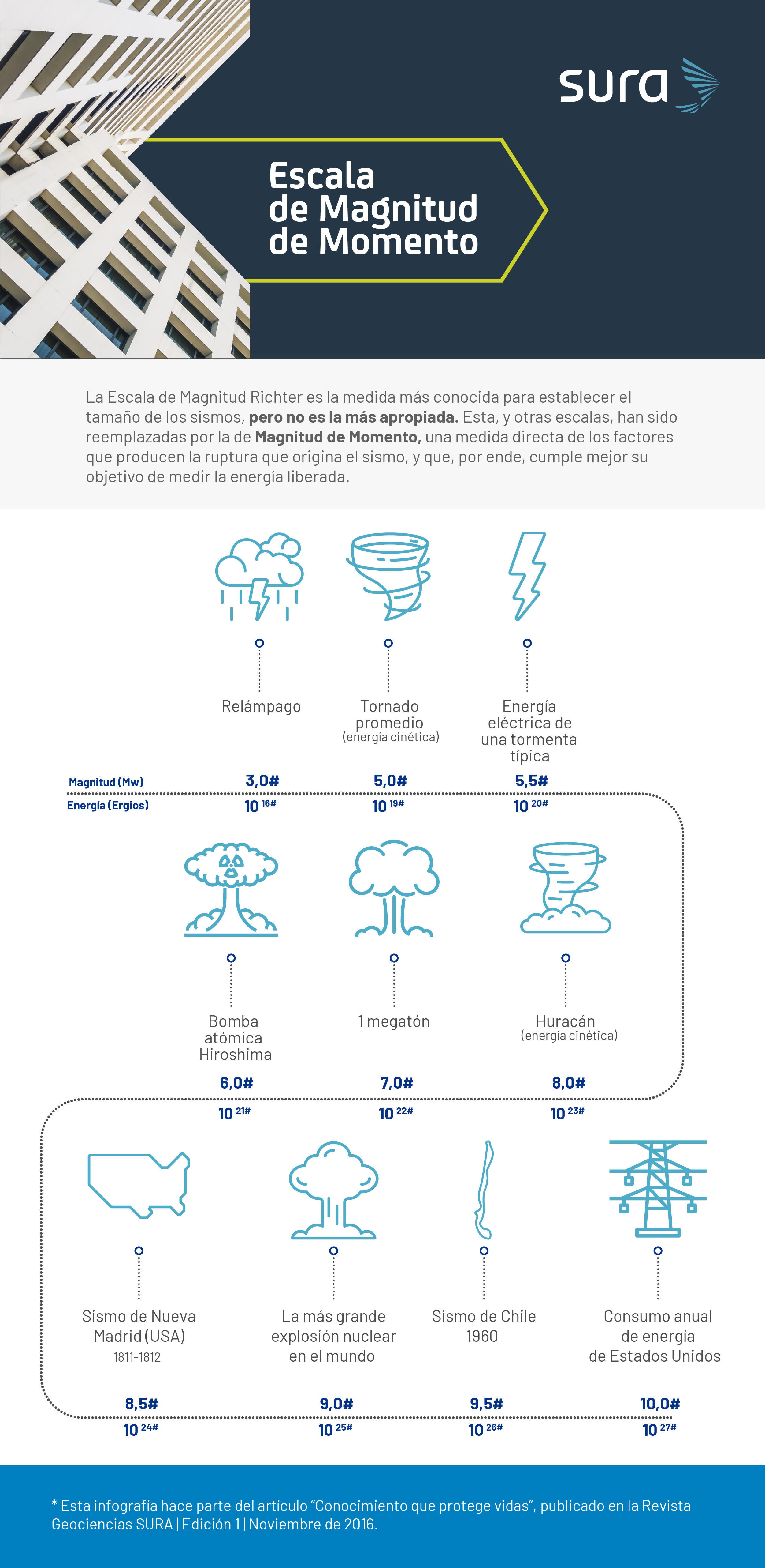
The Richter magnitude scale is the best known measure for establishing the size of earthquakes, but it is not the most appropriate. This and other scales have been replaced by the Moment Magnitude scale., a direct measure of the factors that produce the rupture that causes the earthquake, and which, therefore, better fulfills its objective of measuring the energy released.
Moment magnitude measures the size of an earthquake by analyzing the shapes of waves recorded by seismographs. The different shapes and directions of wave motion are recorded on graphs called seismograms, which are used to estimate fault geometry. The amplitudes or wave sizes on seismograms are used to calculate the shear strength of the faulted rock, the area of the fault zone, and the average displacement of the fault.
The strongest instrumentally recorded earthquake occurred in Chile on May 22, 1960, and had a moment magnitude of 9,5 Mw.
What is earthquake intensity?
For an earthquake of a given magnitude, the greater the depth at which the rupture begins, the lower its intensity at the Earth's surface. Seismic waves travel through the Earth's structure for hundreds and thousands of kilometers, and are attenuated with distance.
The oldest intensity measurements, prior to seismic instrumentation, consisted of descriptions of the effects of earthquakes, based on interviews after the event occurred and focused on the perception of the population in the affected areas. This type of measurement involved a significant amount of subjectivity.
The rise of seismic instrumentation (seismographs and accelerographs) has made it possible to measure the intensity of earthquakes in quantitative terms of ground movements.oAmong the aspects with the greatest impact on the variability of these movements, the amplification effects associated with the characteristics of the soil at each site stand out.
“By definition, we try to characterize, on average, the first 30 meters of the soil profile. All infrastructure and buildings rest on the different types of soil. These soil characteristics contribute to attenuating the intensity of the ground movement or, on the contrary, intensifying it,” explains geologist María Mónica Arcila, a specialist in seismic hazards at the Colombian Geological Service.
Given the marked influence that soil effects have shown on earthquakes worldwide, their characterization has become increasingly important. Due to the growing need to know in greater detail the seismic response of soils and their effects on the seismic intensities transmitted to buildings, seismic microzonation studies have been developed in many countries around the world such as the United States, Japan, India, Turkey and some in Latin America.
A good example of this type of studies are those carried out in Colombia, where the design and construction standards for earthquake-resistant buildings include minimum requirements for their development. Thanks to this, Currently in Colombia the main cities have seismic microzonation studies.
Knowledge of the probability of exceeding certain levels of intensity of seismic movements at a site of interest is the basis for the vulnerability assessment of existing and future infrastructure and buildings.
Why monitor earthquakes?
Many earthquakes occur every day in different parts of the world, but most of them are not perceptible to people due to their low magnitude or great depth. Seismic instrumentation makes it possible to record them, facilitating monitoring, research and the dissemination of seismic knowledge.
A good example of current seismic instrumentation is the Global Seismographic Network, composed of more than 150 modern seismic stations distributed globally and connected by telecommunications network.This network is the result of cooperation between a group of institutions, including the United States Geological Survey (USGS), the National Science Foundation (NSF) and the Institute for Research in Seismology (IRIS).
There are also local instrumentation networks in the countries. One example of this type of network is the Colombian National Seismological Network (RSNC) of the Colombian Geological Service (SGC), made up of 50 seismological stations that transmit data in real time. The SGC also has the Colombian National Accelerograph Network (RNAC), made up of 120 digital devices (of which 32 are located in Bogotá) and aimed at recording intense earthquakes that occur in the national territory. These records are a fundamental part of the country's seismic hazard studies.
In the case of Colombia, there are also local networks of accelerographs, such as the Medellín Accelerograph Network (RAM) and its Metropolitan Area (RAVA), made up of 32 teams (22 located in Medellín), which have been vital in the seismic microzonation studies of the Aburrá Valley.
Based on all the information generated by geological services and organizations dedicated to monitoring earthquakes, relevant information on seismic activity is displayed. “Geological services allow us to advance seismic knowledge for the development of earthquake resistance codes, disseminate information for disaster prevention and response offices, and support seismic risk management mechanisms,” explains geologist María Mónica Arcila.
Other ways to study earthquakes
Instrumental records of earthquakes are generally very recent, which makes it necessary to resort to history to collect data and conduct seismic hazard studies. In Colombia, for example, the first record dates back to 1566, with a historical account. This collection of information is called historical seismicity and complements instrumental seismicity.
There is another alternative of knowledge: paleoseismicity, which refers to the contribution of geology and archaeology. It involves searching in the soil layers for evidence of seismic movements that occurred in the past by using techniques such as Carbon 14. (radiocarbon dating method for organic samples up to 45 thousand years old).
“It is a journey back in time to a time long before recorded history. In this way, we have the possibility of learning about earthquakes that have occurred for which there are no records. This information is very valuable for characterizing the seismic threat of a region,” says engineer Gloria María Estrada Álvarez.
Seismic study has experienced notable advances in recent decades, both in the technology used to analyze each earthquake and in the conclusions obtained from historical records. However, “in the current state of science, Nowhere in the world is it possible to predict the occurrence of an earthquake, understanding prediction as the day, time, place and magnitude, but it is possible to manage the risk, based on the probabilities of occurrence. and the probable characteristics that the movements may have. The role of seismological networks is to generate this knowledge,” explains geologist María Mónica Arcila.
According to data from the Colombian Geological Service (SGC), Every year in Colombia, an average of seven earthquakes of magnitudes between 5,0 and 5,9 Mw are recorded, and one between 6,0 and 6,9 Mw.Since 1964, when modern instrumentation began, six earthquakes of magnitudes between 7,0 and 8,0 Mw and one of magnitude 8,1 Mw have been recorded.
Seismic movements are the result of the accumulation of stresses and their conditions and characteristics are increasingly known in more detail; thus, it is possible to determine where they are generated, what their seismic cycle is and with this information, hazard maps are drawn up in terms of probability.
Fonts
- Maria Monica Arcila Rivera. Geologist from the University of Caldas. Associated with the Colombian Geological Service since 1991.
- Gloria Maria Estrada Alvarez. Civil engineer, specialist in Environmental Engineering, specialist and M.Sc. in Earthquake-Resistant Engineering.