
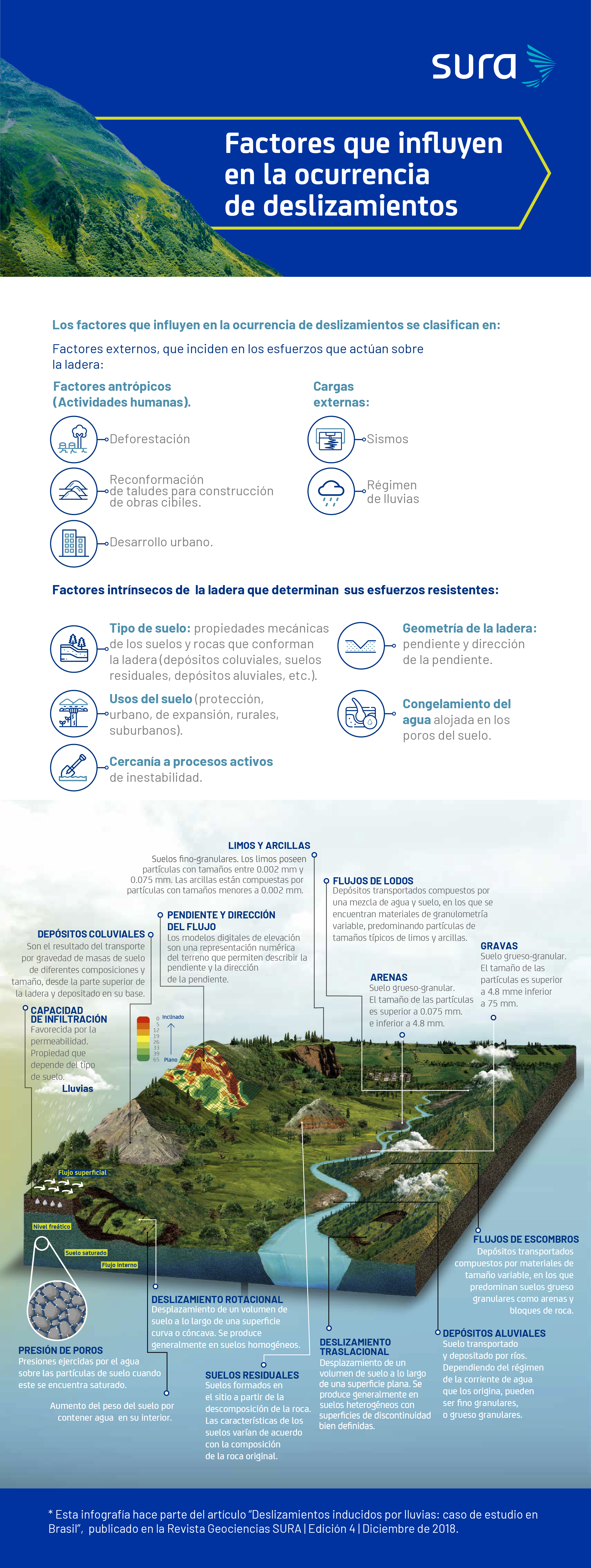
A landslide, or mass movement, is the displacement of a certain volume of material towards lower levels of a slope. This phenomenon occurs due to the loss of equilibrium between the acting stresses, imposed by gravity or other loads, and the resisting stresses of the slope material.
* This article was published in Geociencias SURA Journal | Issue 4 | December 2018.
Effects of water on soil and its potential to induce landslides
The presence of water in the soil is a factor present in most landslides, since it causes an increase in the acting stresses and loss of resistance of the soils on the slope.
The relationship between rainfall intensity and the water storage capacity of the soil are determinants of the occurrence of different types of landslides.If the intensity of the rainfall is greater than the water storage capacity of the soil, surface saturation will occur rapidly, a situation that will favor superficial landslides.
On the other hand, in the case of less intense but longer lasting rains, soil saturation can reach deeper strata, leading to deep landslides.
The rate of movement of the sliding material when a slope fails can vary from a few millimetres per hour to rapid slides, in which large movements are generated in a few seconds.
Landslides are a frequently occurring global phenomenon and are significantly favoured by climatic and geomorphological conditions. Different institutions such as the National Aeronautics and Space Administration (NASA) or the Disaster Effects Inventory System –DesInventar–, are dedicated to monitoring and recording historical landslides from a local to a global scale.
The landslide inventories developed by these institutions represent a valuable source of information for understanding the phenomenon and the local variables that influence its occurrence, and facilitate the development of risk assessment, monitoring and management models.
The Global Landslide Catalogue (GLC) contains a compilation of all historical rainfall-induced landslides that have been reported in the media, disaster databases, scientific reports, or other sources. The GLC was developed at NASA's Goddard Space Flight Center since 2007.
What happened in Rio de Janeiro on January 11, 2011?
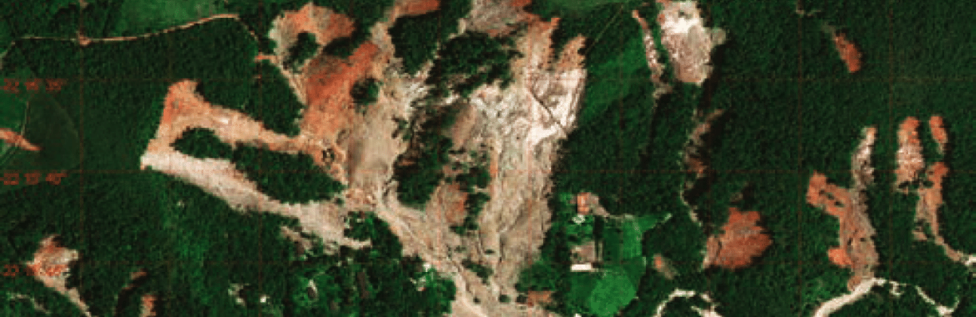
One of the most significant cases of rain-induced landslides in South America occurred on January 11 and 12, 2011 in the mountainous region of Rio de Janeiro. This case was classified by the UN as the eighth largest landslide in the world in the last 100 years..
Some key aspects of the occurrence of multiple landslides in this region of Rio de Janeiro in 2011 were:
- Steep or mountainous topography with high slopes.
- Slopes made up of soils with a high susceptibility to loss of resistance due to water saturation. Anthropic factors that generated deforestation and reconfiguration of slopes to allow urban development in the area.
- Heavy rains. According to data from the National Institute of Meteorology, rainfall of 280 mm was recorded in a 24-hour period between January 11 and 12, 2011 in the city of Nova Friburgo. For comparative purposes, it is important to mention that the historical average rainfall associated with the month of January in this city is 277 mm, which indicates that the rainfall generated in 24 hours was similar to the historical average for the month. This high volume of rainfall caused approximately 3.500 landslides in the area, mainly of the superficial translational type and debris flows.
How to manage the risk of rain-induced landslides?
In the global and local context, there are numerous investigations that, together with technological advances in monitoring hydrometeorological variables and the state of the art in semantic engines for tracking online news, show a very positive path for managing the risk of landslides associated with rainfall.
The fundamental key is focused on the processing of information on the factors that control the acting and resisting stresses of the slopes, together with the estimation of representative thresholds of intensity-duration of the rains that can trigger landslides in a specific area. This path allows validating predictive landslide models useful for:
- Landslide early warning systems.
- Design and construction of engineering works to control unstable or potentially unstable areas.
- Land use plans that guide the most appropriate land uses for areas susceptible to landslides.
These analysis techniques, combined with ground-based instrumentation and remote sensors, show great potential for better understanding these phenomena, and thus better managing their related risks.With what is known today about the mechanisms of occurrence of landslides triggered by rain, it is possible to plan and implement concrete actions with a good level of information.
The important thing is not to lose sight of the fact that these are dynamic processes that depend not only on the physical conditions of nature, but also on urban development in the area of interest. Analysis models will continue to improve to estimate with increasing accuracy the patterns of intensity and duration of rainfall that induce landslides. The important thing is to know that there are mechanisms today to analyze and manage this risk with a view that combines regional and local aspects, and that in turn allows decisions to be guided in the most favorable direction to protect life, property and productivity.
Fonts
- Gabriel R. Toro. Civil Engineer from the National University of Colombia, M.Sc. and Ph.D. in Civil Engineering from the Massachusetts Institute of Technology.
- Kevin B. Clahan. Bachelor of Science in Earth Sciences from the University of California and M.Sc. in Geology from San Jose State University.