
Various investigations into earthquake-induced landslides confirm the importance and potential impact of these phenomena on the world. Timely risk management allows for preparation, both to protect the population and to minimize associated material losses.
* This article was published in Geociencias SURA Journal | Issue 2 | September 2017.
Landslides usually occur in various geographic locations as part of the natural evolution of the landscape. Many occur on natural slopes, but they also occur on man-made slopes. Although their causes vary, a significant percentage of them are generated by the occurrence of seismic events.
When there is an earthquake, the ground movements produced by it are often sufficient to cause the failure of slopes or embankments. that were previously in marginally stable or moderately stable conditionsAssociated damage can range from minor to major landslides, depending on the geometry and material characteristics of the slopes.
Can a seismic event induce landslides?
To answer this question, it is necessary to know the factors that control the susceptibility of a slope to landslides, as well as the effects generated by seismic waves. Historical records of earthquake-induced landslides are very useful evidence to understand their mechanisms of occurrence and, therefore, to identify the most efficient actions for their mitigation.
The landslide potential of a slope depends on many factors, among which the following stand out: geological and hydrological conditions, land uses, topography (height, slopes and direction of slopes), climate, resistance characteristics of the soil or rock profile and moisture content.
When there is an unfavorable combination of these factors, the terrain is prone to landslides. However, a number of external factors such as seismic events, heavy rainfall, and human activities such as deforestation, agriculture, and infrastructure construction can trigger landslides.
It is important to take into account some indicators of instability of a slope or hillside, which if not managed properly could trigger a landslide.The areas where these manifestations occur are more prone to landslides when a seismic event occurs.
On slopes on the ground:
- Doors and windows leaning or having difficulty closing them.
- Cracks, settlement and inclination of buildings.
- Tensile cracks in the crown of the slope or hillside outlining the failure surface.
- Collapse of the slope crown.
- Leaning or curved trees or posts.
- Bulge at the base of the slope or hillside.
- Fault surface.
On rocky slopes:
- High density of fractures and discontinuities or evidence of material detachment.
Various investigations have studied earthquake-induced landslides throughout history. The first formal scientific study on the subject was conducted in 1783 for landslides induced by a series of earthquakes in Calabria, Italy. More recently, in 1984, David K. Keefer published a study in which he analyzed the correlation between more than 300 earthquakes in the United States (1958-1980) and the landslides induced by them.
In this study, some important correlations were obtained between the seismic magnitude and variables such as: a) areas affected by the induced landslides, b) maximum distance between the induced landslides and the epicenter, c) types of landslides generated, among others. These studies have provided the basis for a growing body of research into the variables that trigger landslides associated with earthquakes., which continue to be carried out today.
Earthquake-induced landslides in El Salvador
Various investigations into earthquake-induced landslides confirm the importance and potential impact of these phenomena on the world. One case worth mentioning in Central America is the earthquake-induced landslides that affected El Salvador on January 13, 2001.
This earthquake, which had a magnitude of 7.6 (Mw) and occurred at a depth of 60 km, and its associated landslides, affected tens of thousands of homes and buildings, energy infrastructure, road infrastructure and agriculture. It is important to mention the large number of landslides that occurred on steep slopes, mainly in the Balsamo mountain range.
Earthquake-induced landslides in Nepal
Another clear, very recent example of earthquake-induced landslides occurred in Nepal in April 2015, where an earthquake with a magnitude of 7.8 (Mw) at a depth of 15 km, with its epicenter in the Kathmandu Valley, caused more than six thousand landslides and economic losses of billions of dollars in the cities that make up this valley.
The characteristics of the recorded event and the distribution of damage and landslides caused showed the importance of the amplification of the earthquake due to topographical effects and the type of soil., because this region has a complex topography, with steep slopes and soft soils of different types.
Earthquake-induced landslides in Colombia
In the specific case of Colombia, there are a significant number of records of landslides that have been triggered by the action of different seismic events. Some can be cited, such as the Murindó earthquake on October 18, 1992 with a magnitude of 7.1 (Mw), which caused numerous landslides on the banks of the Murindó River, causing it to become a dammed river.
A similar case occurred on June 6, 1994, when an earthquake with a magnitude of 6.8 (Mw) with its epicenter in the Páez River basin, induced large landslides, generating an avalanche that devastated a large part of the municipality of Páez, taking with it nearly 40.000 hectares of land.
How to manage the risk of earthquake-induced landslides?
To properly manage the susceptibility of earthquake-induced landslides, the development of technical and the preparation of inventories of active landslides focused on defining areas with different levels of threat in the region of interest.
Landslide hazard maps are relevant for the planning, execution or rehabilitation of infrastructure and building works, as well as for the quantification of associated risks, which are the basis for evaluating the cost-benefit ratio of possible prevention and mitigation alternatives, as highlighted by M.Sc. Gabriel Toro, a researcher and advisor recognized for his contributions to seismic engineering.
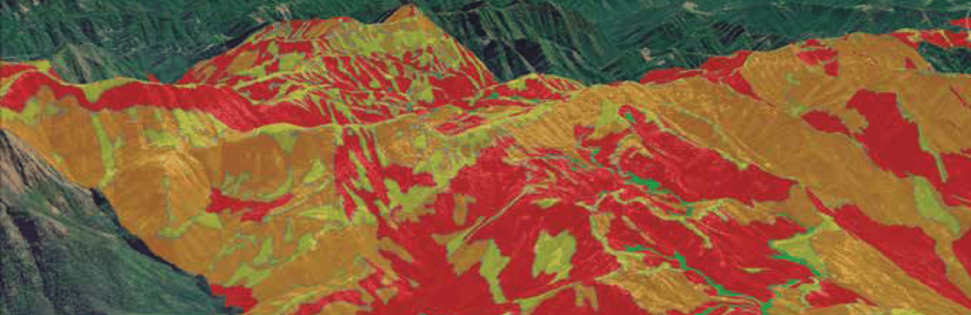
Respecto a seismic scenario modeling to estimate landslide risk levels, lCities can prepare to protect their populations and minimize property losses associated with earthquake-induced landslides. A clear example of this is the work carried out by the local government of the city of Aizawl, Mizoram, India, which has been affected by earthquake-induced landslides in the past.
In order to obtain some recommendations for managing this risk and protecting the population, its buildings and infrastructure, a series of technical studies were carried out in which M.Sc. Kevin Clahan, principal geological engineer of the American company Lettis Consultants International, Inc. and a team of specialists in seismology, geology, geotechnics and structures, analyzed a scenario of a probable earthquake in this city, the potential associated landslides and the expected losses.
One of the key results of this study was the landslide hazard zoning map induced by the earthquake scenario analyzed, which provides essential elements to guide land use and urban development plans in a structured manner..
Landslide hazard maps are relevant for the planning, execution or rehabilitation of infrastructure and building works, as well as for the quantification of associated risks, which are the basis for evaluating the cost-benefit ratio of possible prevention and mitigation alternatives.

Fonts
- Gabriel R. Toro. Civil Engineer from the National University of Colombia, M.Sc. and Ph.D. in Civil Engineering from the Massachusetts Institute of Technology.
- Kevin B. Clahan. Bachelor of Science in Earth Sciences from the University of California and M.Sc. in Geology from San Jose State University.