SURA firmly believes in the importance of nature as a source of trends and risks. Therefore, knowing and understanding its dynamics opens up a world of management possibilities for the well-being and sustainable development of society, people and companies.
* This article was published in Geociencias SURA Journal | Issue 5 | September 2019.
The Global Earthquake Model (GEM) Foundation is a non-profit organization established in 2009 with the purpose of creating a more earthquake-resilient world. GEM's mission is to become one of the most comprehensive and globally accepted sources of knowledge on seismic risk., and ensure that its products are applied in seismic risk management worldwide.
The development of society and the exchange of knowledge are an integral part of the GEM principles (open, collaborative, credible and public good), principles with which SURA connects.
SURA's alliance with GEM was born within the framework of the great challenge of knowing and understanding nature and its dynamics, as a means of observation regarding seismic threats and risks. SURA is working in collaboration with GEM to take advantage of science and data to make all this knowledge available to people and companies, in order to contribute to the construction of resilient cities.
GEM has conducted more than 50 training workshops and capacity building sessions with experts from each region around the world. SURA has participated in more than 5 workshops held in Latin America, one of which was held at its facilities in Medellin in 2013.
Managing seismic resilience around the world
GEM aims to increase the resilience of communities to seismic events. To achieve this goal, the foundation has focused its efforts not only on calculating the threat and seismic risk and on estimating the social and economic factors that can increase physical damage, but also on developing tools and exchanging knowledge that allow governments and business decision-makers to work on prevention, recovery and the potentialization of new capacities, protecting people and saving lives.
In line with the above, On December 5, 2018, GEM launched the “Global Seismic Hazard and Risk Model,” which provides a benchmark for assessing seismic risk.This model, which is comparable worldwide and is in the public domain, has the following components:
Threat: It allows us to observe which areas of the world have a greater or lesser probability of seismic events occurring.
Exhibition: classifies the number of people and the number of buildings globally according to their use (residential, industrial and commercial) and their physical characteristics (construction material and number of floors).
Vulnerability: characterizes the behavior of buildings in the event of possible earthquakes, according to the physical properties of each structure.
Earthquakes know no borders. For this reason, experts from each country (scientists and engineers), led by the GEM Foundation, joined forces to build a common model. In the words of Ph. D. John Schneider: “The inclusion of local experts is of vital importance to achieve acceptance of the models developed at local, national and regional levels. This participation promotes a sense of ownership of the risk by the community and is essential to achieve that communities raise public awareness and mitigate or reduce the risk.”
Collaboration between the public, private and academic sectors was key to the development of the global seismic hazard and risk model, in which research centers, disaster prevention organizations and private sponsors, such as SURA, were involved. Thanks to this multiplicity of professional actors, different investigations were carried out that served as input in the development of the global model.
According to Ph. D. Marco Pagani, the foundation's Hazard Coordinator, “the seismic risk map, developed by GEM, constitutes the first major global effort since 1999, when the first seismic hazard initiative was carried out by the Global Seismic Hazard Assessment Program” (GSHAP).
The following were used in the development of the model:
- Standardized data on over 20.000 major earthquakes that have occurred worldwide over the past 110 years.
- Information from 70.000 GPS stations.
- Specific information about major active faults.
- Data on buildings and infrastructure around the world and on people's vulnerability to earthquakes. With all this information, people and companies can make better decisions for seismic risk management and be better prepared to avoid unfavorable consequences that impact the development and continuity of their operations.
The maps will be uploaded to the GeoSURA platform, which SURA makes available to its clients. There, in addition to viewing these maps, users will be able to combine information about their location with other data that the platform contains. In this way, they will be able to make informed decisions with a more comprehensive view.
How to access the information?
The foundation has made the OpenQuake platform publicly available, offering an interactive environment through which users can access information, share data and explore the models and tools developed by GEM for integrated seismic risk assessment. SURA, with its Geosciences area, manages the platform and supports clients in seismic risk analysis, facilitating interaction and analysis of information.
Calculate: allows users to access the different tools developed by GEM to perform seismic hazard and risk modelling and calculations.
Share Through this module, users can share information and complement existing data sets.
To explore: It allows users to consult, explore and access information, and offers tools available for comprehensive seismic risk assessment.
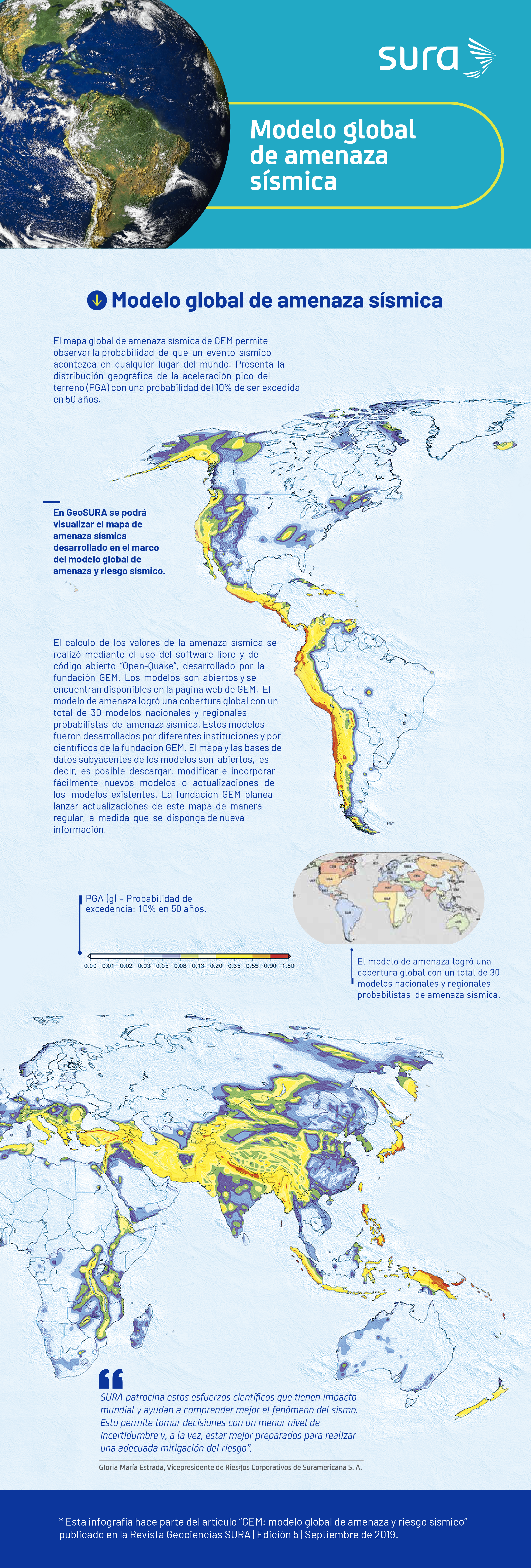
Global seismic hazard model
GEM's global seismic hazard map allows you to see the probability of a seismic event occurring anywhere in the world. It presents the geographic distribution of peak ground acceleration (PGA) with a 10% probability of being exceeded in 50 years.
The calculation of seismic hazard values was carried out using the free and open source software “OpenQuake”, developed by the GEM Foundation. The models are open and available on the GEM website.
The hazard model achieved global coverage with a total of 30 national and regional probabilistic seismic hazard models. These models were developed by different institutions and by scientists from the GEM Foundation.
The map and underlying databases of the models are open, meaning that new models or updates to existing models can be easily downloaded, modified and incorporated. The GEM Foundation plans to release updates to this map on a regular basis as new information becomes available.
Global seismic risk map
Global exposure map: shows the geographic distribution of residential, commercial and industrial buildings in each country. Its development took into account information on the type of building material, the number of floors and local construction practices (such as the percentage of use of local earthquake-resistant standards).
Global map of loss of life due to earthquake: It shows an estimate of the average annual human losses due to excessive damage or structural collapse of buildings caused by an earthquake.
Global seismic risk map: presents the geographic distribution of average annual losses in USD. In order to obtain a global map where the values for each country are comparable, these values were standardized in relation to the average construction costs of each country.
The GEM Hazard Map is intended to be a dynamic product that can be updated as new data sets and models become available. Technical details on the compilation of the hazard and risk maps and the underlying models are available at www.globalquakemodel.org/gem
What are the benefits of the model?
These are some of the benefits of the model that allow for the prevention of seismic risk and become inputs for strategic decision-making:
- It provides greater knowledge and understanding of seismic risk in all its dimensions: characteristics of the threat at local and regional levels, exposure of people and property, physical and social vulnerability. With this information, regulatory bodies can propose better strategies to mitigate the effects of earthquakes.
- It allows disaster prevention and response agencies to build action and preparation plans for emergency response.
- Stimulates investment in the creation of cities and communities resilient to seismic effects.
- It facilitates greater knowledge of the physical vulnerability of structures in each region, providing the opportunity to prioritize efforts and encourage structural improvement and rehabilitation programs.
- It allows the creation of regional and local risk maps, useful for managing the adoption of mitigation measures.
- Promotes strategies that educate and raise awareness in communities about the importance of reducing risk.
- Supports urban development or structuring in land use plans.
GEM after the global model
The Foundation will continue to strongly promote the development and improvement of models and tools for global seismic risk assessment, incorporating annual model updates. The “global social vulnerability and integrated risk map” (SVIR) will be launched in December 2019.. In addition, it will work on other natural phenomena, such as floods, volcanoes, tsunamis and landslides, in order to make OpenQuake a tool applicable to the assessment of multiple risks.
Fonts
- Ana Maria Cortes Zapata. Mathematical Engineer and M.Sc. in Applied Mathematics from EAFIT University.
- John SchneiderGeophysicist from the University of California (San Diego, United States), Ph. D. in Geophysics from the University of Wisconsin.
- Marco Pagani. M. Sc. in Geological Sciences and Ph. D. in Earth Sciences from the University of Milan.
- Victor Silva. M. Sc. in Structural Engineering and Ph. D. in Risk Engineering from the University of Aveiro (Portugal).