
Fire is an element that has been present since the beginning of humanity and has been fundamental in the development of life on planet Earth. Its role has been predominant in the evolution of human beings and in the dynamics of many of the most important ecosystems in nature. However, forest fires have great impacts on ecosystems. Knowing them is necessary to mitigate their damage.
* This article was published in Geociencias SURA Journal | Issue 5 | September 2019.
What is a forest fire?
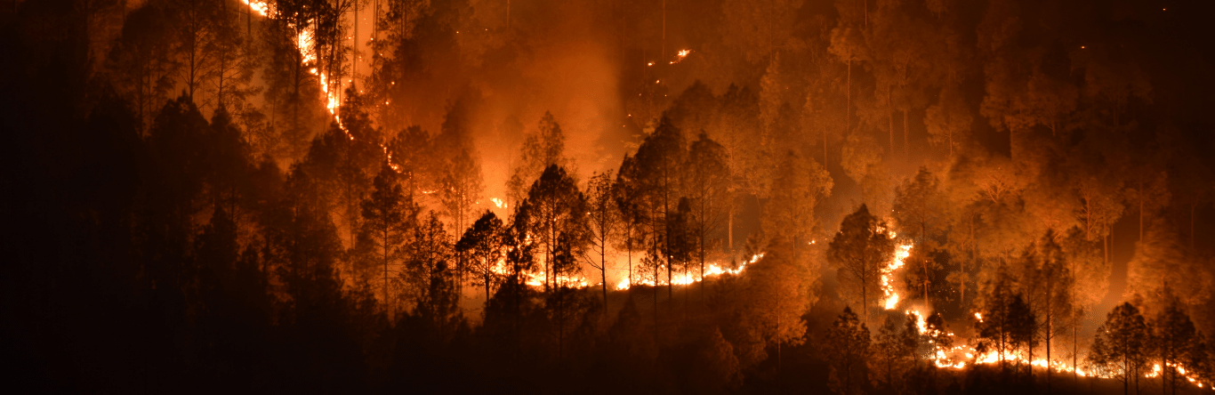
Forest fires are uncontrollable fires fueled by climatic conditions such as humidity and wind speed. They occur on all continents of the planet Earth, have a strong impact on forested areas and the great plains and are among the most critical and frequent natural disasters.
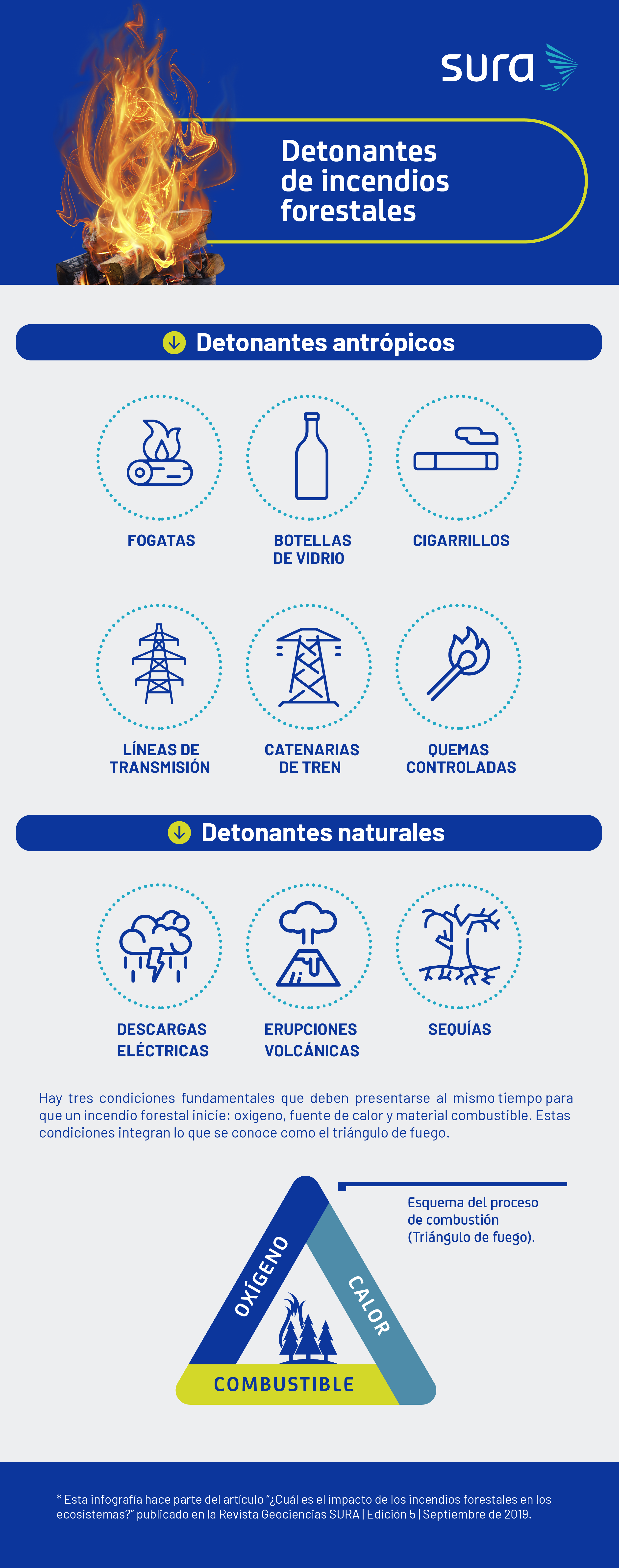
These phenomena are caused by natural agents such as atmospheric electrical discharges or volcanic eruptions. However, in most cases, they are caused by human activity.. Among the most frequent causes are waste in wooded areas that cause sparks or ignition points when in contact with the sun, for example: glass bottles, cigarette butts, bonfires, fireworks, power transmission lines or railway catenaries that generate direct contact points with the surrounding nature; even controlled burns for soil fertilization for productive purposes can get out of control and cause fires.
What are the types of forest fires?
There are three types of forest fires that vary depending on the location of the fires, the severity of the phenomenon and the speed of their spread:
Underground: The combustible material of this type of fire is composed of compacted forest residues on the ground, such as leaves or decomposing wood. The fire spreads slowly due to the absence of wind in the subsoil of the forests. It is difficult to extinguish the flames due to the depth at which the strata of organic matter present in the soil are found.
Surface fire: Its flames spread only over the surface of the land. It is the fire that causes the least damage to forests and is easier to control.
Crown or cup fire: It spreads through the tops of trees more quickly than surface fires. Wind speed is key to the level of impact on the area.
How is a forest fire mitigated and controlled?
After understanding how forest fires form and the essential elements for creating fire, The basic strategy to control them is to interrupt one of the three elements that form part of the fire triangle (oxygen, heat or fuel).This interruption is carried out using different methods, depending on the objective or element that is to be suspended. These intervention methods can be direct or indirect, depending on the action front.
Control and mitigation methods can be complementary to each other. By applying them, it is possible to have complete control of the affected area and stop the spread of the flames in the surrounding area.
Actions to detect forest fire outbreaks are the first step to successfully extinguishing the fires. The sooner they are detected, the more effective the extinguishing operations will be and the fewer damages will occur.
Heat
The use of water in fighting forest fires is the most effective method for reducing the heat generated during combustion. Water and its ability to absorb heat through evaporation are a key factor in controlling flames. When the resource is available, it is considered a direct method of fire control.
However, in conditions where there are topographical difficulties in accessing the resource, the use of water or chemical retardants is indirect and is achieved by building firebreaks with water or retardants that prevent plant ignition in areas close to the event.
Fuel Efficiency:
The great difficulties in completely eliminating oxygen in the air and the low availability of water as a resource for controlling fires mean that the greatest efforts are focused on removing combustible material from the potentially affected area. To do this, there are several tasks that are carried out beforehand, such as creating firebreaks in large forest plantations and natural wooded areas that interrupt the vegetation and eliminate all material that could serve as fuel in a strip several metres wide; in this way the fire is prevented from spreading.
Another alternative for the elimination of combustible material is controlled burning or “fire strips”, which consist of strips of land in the path of the fire where any combustible agent that could fuel the fire is eliminated by means of controlled fire. These actions are intended to eliminate the fuel by establishing a fence around the fire, thus preventing the fire from spreading to larger areas.
Oxygen
To eliminate this element, what is commonly done is to cover the combustible material that is on fire with a layer of earth.. Also, the oxygen present can be replaced with water vapor. This is a direct intervention method and can be applied in the case of forest fires of low-lying plant material, in the initial stage of fires or for the control of isolated outbreaks in larger situations.
The wildfire that occurred in California (United States) in 2017 shows the impact that this type of event can have on climate change. In one week, this event released the equivalent of all the gases that cars and trucks in California would emit in a period of one year.
Equipment and instrumentation for control
Governments and departments in charge of conservation and preservation of ecosystems in countries should be prepared to combat forest fire seasons that occur in their territories. Companies and individuals who own large tracts of land should also do the same. To do so, it is essential to have equipment and infrastructure that allow adequate response to the event in the shortest possible time to reduce the affected area.
Aerial detection
Small aircraft are used to provide a broad view of the area. The pilot is accompanied by an observer who is responsible for taking data on all fire outbreaks detected by the aircraft. The advantage of this method is the large area that can be observed; its greatest difficulty is the operating costs it generates.
Heavy machinery and vehicles
Helicopters and small aircraft for transporting personnel, equipment, water and fire retardant chemicals. Due to their great versatility in remote terrain, helicopters are one of the main vehicles used during a wildfire emergency.
Fixed terrestrial
They are watchtowers built of wood, which are located at a great height, on hills that allow an extensive view of plantations and reserves. The monitoring exercise It is constant and, once fire outbreaks occur, forest rangers can quickly identify the exact location of the event and communicate with the entities responsible for fire response.
Television systems
These are closed circuit television systems that can be installed in the vicinity of critical areas most vulnerable to forest fires. They can be installed on surveillance towers, posts, aircraft and have a 360-degree view. They also require an alternate control center where personnel can observe all the installed cameras and notify the authorities of possible events.
Hand tools for ground suppression
Axes, shovels, rakes, chainsaws, portable water pumps, flamethrowers and torches.
Land mobile
These are groups of surveillance personnel within forest plantations or nature reserves, who make a specific route on foot or by suitable means of transport. Observation is not continuous, as the group will pass by the same place from time to time.
Satellite detection
In remote areas or in populations that do not have the availability or resources to deploy detection mechanisms, satellite images are the most reliable source to determine and observe how forest fires develop.
Images generated by satellites on international missions are a valuable source of information for monitoring events and also for the academic and research community. Monitoring events through satellite images is a slower process than all the previous ones, due to the time that satellites pass through the same area, the cloud conditions in the atmosphere and the processing of the information obtained.
However, satellites can provide information on physical variables relevant to the preventive control of forest fires, such as the moisture content in vegetation or changes in vegetation conditions. In addition, after an event, they can monitor how an area is recovering and specify, exactly, the affected territory.
When fires are of great magnitude and cover large areas, it is necessary to use aircraft with a greater capacity, such as air tankers. These are military aircraft with a large capacity to transport water and a range of movement that are adapted to combat large events. They even provide international support in areas that do not have aircraft of this type.
What is the impact of forest fires?
The damage caused by forest fires to ecosystems and the environment is related to the recurrence, severity, intensity and duration of the fire. intensity Fire is associated with the energy released in the forest fire and is expressed in terms of heat (calories) or power (watts); severity, for its part, with the effects that this generates on the environment and ecosystems.
The impacts of forest fires can be:
- Direct: animal mortality, vegetation and soil degradation.
- Indirect: habitat modification, species migration, population decline, soil erosion, water pollution and landslides.
On the floor
The physical, chemical and biological properties of soils can be affected during a forest fire and this could have consequences for the development of ecosystems. The level of intensity of the fire released during the combustion process, the thickness of the soil and the temperature at which its properties change will determine the effects on the soil.
Soil structure is the most relevant physical factor affected by forest fires, since it can generate an increase in soil density and a reduction in porosity (empty spaces occupied by air or water particles). This leads to a decrease in soil productivity, due to the interruption of water infiltration capacity and irreversible damage to organic matter.
Other physical and chemical properties that soils may suffer due to a forest fire are:
- Moisture retention capacity.
- Change in nutrient contents.
- Expulsion of elements into the atmosphere (gas emission).
- Erosion of the affected soil.
- Loss of forest soil due to combustion.
- Reduction or loss of the organic layer.
- Increased runoff (rainwater flowing freely over the surface of a land).
- Alteration (or loss) of microorganisms and their dynamics in soil composition.
- Partial or total removal or degradation of plant roots.
- Degree of acidity or basicity (pH).
- Electric conductivity.
- Texture.
- Porosity.
In the air and in the atmosphere
Due to their intense and destructive nature, forest fires can release large amounts of greenhouse gases into the atmosphere in a short period of time, compared to other sources of greenhouse gases.
Smoke is a consequence of the combustion of forests and ecosystems that has implications for local air quality and climatic conditions.The emission of organic compounds into the atmosphere and greenhouse gases in a forest fire contributes to global warming and, in turn, to the destruction of forests and forest environments., since it directly alters the mechanisms for removing CO2 from the environment. It also reduces visibility, which negatively affects air and land traffic.
In water
Forest fires affect all processes of the hydrological cycle: interception, infiltration, evapotranspiration, soil moisture retention and natural water flows. In addition, they contribute to the loss of plant material and the degradation of the physical and chemical properties of soils, which largely determine how the natural water cycle will be impacted. Changes in organic material and soil cover in watersheds due to forest fires also have implications for this cycle.
Case study: Chilean firestorm (2017)
How did the event occur?
Between January and February 2017, a particular phenomenon occurred in the Chilean regions of Coquimbo, Valparaíso, O'Higgins, Maule, Biobío and Araucanía during the forest fire season.
Between January 1 and February 10, nearly 520 hectares were burned, of which 75% of the area was made up of forest ecosystems, including nature reserves and commercial plantations.
Which regions were most affected?
Maule was the area most affected by forest fires, with a 54% share of the total area consumed, followed by Biobío and O'Higgins, with 19% and 17%, respectively. The most affected area, called the "Las Máquinas Fire Complex", covered an area of 187 thousand hectares. In this sector, around 14 thousand hectares were consumed in 115 hours, which indicates an advance of 8.142 hectares per hour.
This phenomenon, called “Firestorm”, developed between the afternoon of January 25 and the early morning of January 26, 2017. During that time window, fires throughout the region exceeded intensities of around 60.000 kW/m and maximum propagation speeds of over 6 km/h. This particular phenomenon occurred during the summer in the southern hemisphere of the American continent and recorded record high temperatures in the central region of Chile and long periods of dry weather.
South Pacific Anticyclone
The presence of an anticyclonic storm* (which increased pressure between the Pacific Ocean and the Andes), the accumulation of hot air and the dryness of the atmosphere due to the fires converged in the “Las Máquinas Fire Complex”, which caused a convective fire environment.
During the night of January 25 and the early morning of January 26, this complex produced winds with intensities close to 100 km/h, according to the analysis of the Civil Protection Mechanism of the European Union. This event altered the atmospheric behaviour of the region and intensified the other fires that were developing in the regions.
The phenomenon in figures
25.021 homes were threatened during the emergency. In total, 2.288 homes were affected.
78,2 billion tons CO2 were the greenhouse gas emissions released into the atmosphere during the event, a figure equivalent to 3,5 times the emissions from the entire vehicle fleet in Chile.
1.300 million It is the cost that the Chilean State had to assume to cover the emergency, reconstruction, restoration and recovery of the impacted area.
Fonts
- Esteban Herrera EstradaCivil engineer from the University of Medellín and specialization student in Earthquake-Resistant Engineering from Eafit University.
- Victor Hugo Angel Marulanda. Systems and Computer Science Engineer from the National University of Colombia, and Project Management specialist from the School of Engineering of Antioquia.